

Canadian Forces Station Armstrong:
Opened in 1954 as Armstrong Air Station of the United States Air Force, with the radar functions being run by No. 914 Aircraft Control & Warning Squadron.
On 1 April 1963 Armstrong was connected to the Semi-Automatic Ground Environment (SAGE) system, and the station became a long-range radar site.
Corresponding with the SAGE conversion, the station was handed over to the Royal Canadian Air Force and re-named RCAF Station Armstrong. This was part of an arrangement with the United States that came as a result of the cancellation of the Avro Arrow. Canada would lease 66 F-101 Voodoo fighters and take over operation of 12 Pinetree radar bases. The new radar unit, 38 AC&W Squadron, continued in the early warning role. It would later be known as 38 Radar Squadron.
The station was re-named CFS Armstrong in 1968.
Improvements in radar technology made the site redundant and the station closed on 1 September 1974.
A recommendation had been made in May 1974 by the last commanding officer of the station, Lieutenant-Colonel J.A. Mitchell, to Air Defence command Headquarters at RCAF Station North Bay, that the Department of National Defence make the property available to the Department of Indian Affairs and Northern Development for use as a residential school, but this was ultimately rejected.
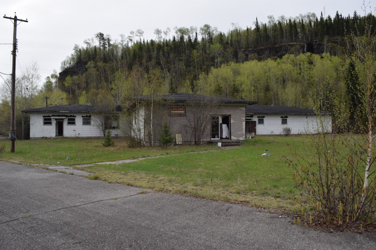
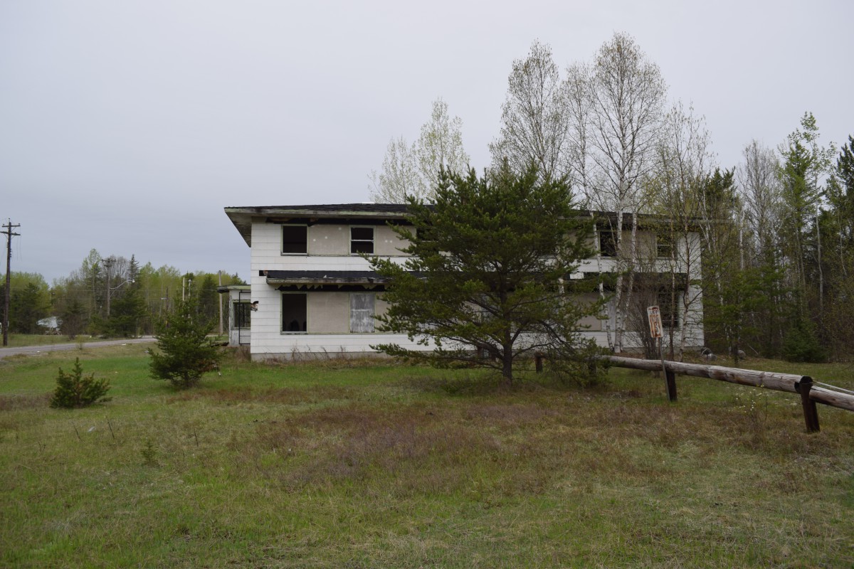
The former station was sold to private owners, who converted it into a residential community, D & L Estates. Most of the buildings were converted into small apartment units and short-term hotel units. The PMQ trailers were retained as single-family residences, and the combined mess was converted into a restaurant and store.
One of the old radar units was converted into a sign, advertising “Welcome to D & L Estates Host to the North.”
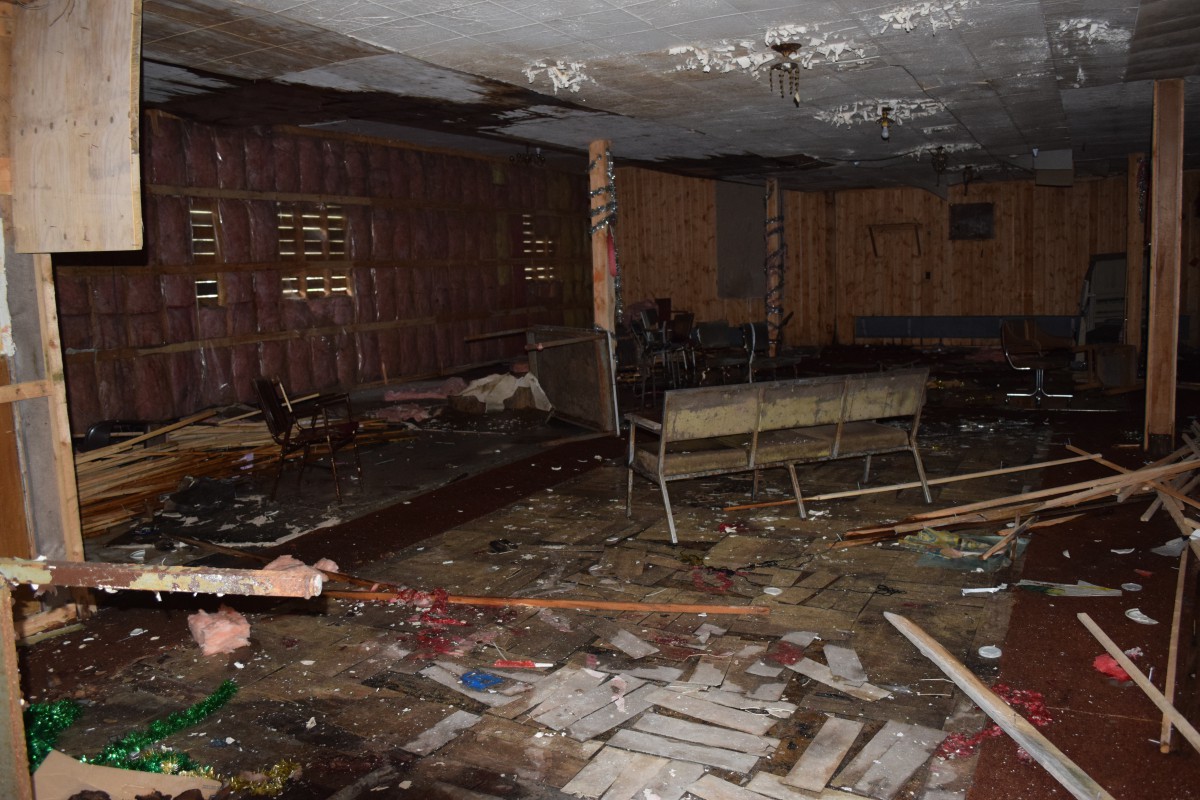
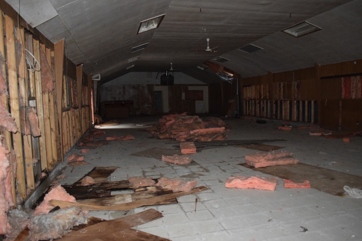
This venture closed in 1993 and the property has been abandoned ever since.
Most of the buildings still remain, but are in poor shape. All but one building appears to remain at the operations site, but the remaining ones are also deteriorating, although not as bad as the wood-frame buildings in the domestic area. Some of the trailers in the PMQ area remain, but are in poor condition.
In December 2013, the then-owners of the property were fined $25, 000 in court after being charged by Environment Canada enforcement officers for failing “…to remove all of the PCB contaminated equipment from the property and to have the PCBs destroyed.”
Additional source material: https://www.canada.ca/en/environment-climate-change/services/environmental-enforcement/notifications/d-l-estates-fined-violation.html, Armstrong, ON – 1974 – Disposal of Property – National Archives of Canada (c-and-e-museum.org).
-

- Containment area, combined mess, barracks and recreation centre, 1955. Photo: Unknown.

-

- Main gate, February 1963. Photo: John Lalonde.

-

- The trailer park at CFS Armstrong, June 1972. Photo: George Clark.

-

- Main gate and entrance to the station. Barracks and the Mess Hall in the background, June 1972. Photo: George Clark.

-

- Remains of the station sign, May 2021. Photo: Bruce Forsyth.

-

- Armstrong HQ, 1971. Photo: Eldon Booth..

-

- Armstrong 1971. Photo: Eldon Booth..

-

- Overview of station. Photo: Unknown.

-

- Overview of station, 14 September 2001. Photo: Bob Wanner.

-

- Officers barracks. (L-R) A/1C David England (1954-1955) and Jack Lunstrum (owner of the property), 14 September 2001. Photo: Bob Wanner.

-

- Operations site, July 2002. Photo: Brian LeRossignol

-

- Remains of FPS 27 radar tower, July 2002. Photo: Brian LeRossignol

-

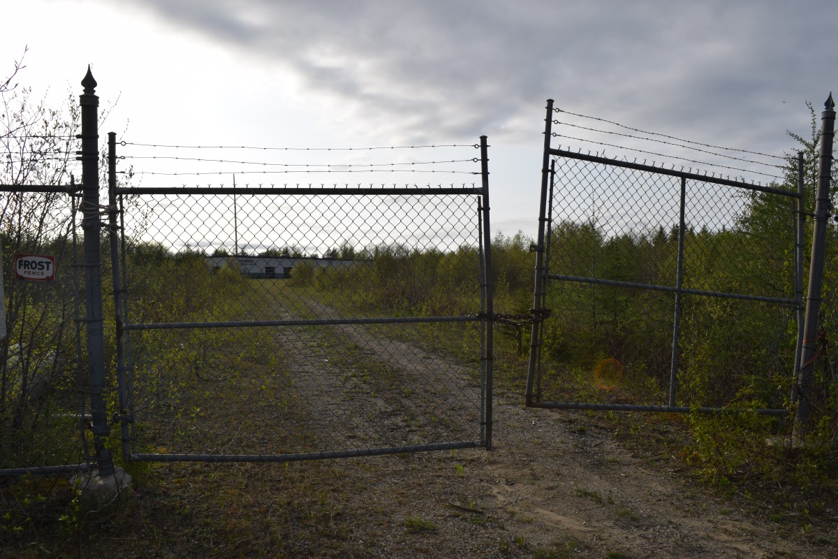
- Main Gate, May 2021. Photo: Bruce Forsyth.

-

- Guardhouse, May 2021. Photo: Bruce Forsyth.

-

- Barracks and combined mess, in 2012. Photo: Unknown.

-

- Barracks in 2012. Photo: Unknown.

-

- Guardhouse, May 2021. Photo: Bruce Forsyth.

-

- Station Headquarters, May 2021. Photo: Bruce Forsyth.

-

- Station Headquarters, May 2021. Photo: Bruce Forsyth.

-

- Barracks, May 2021. Photo: Bruce Forsyth.

-

- Barracks, May 2021. Photo: Bruce Forsyth.

-

- Barracks, May 2021. Photo: Bruce Forsyth.

-

- Barracks, May 2021. Photo: Bruce Forsyth.

-

- Barracks, May 2021. Photo: Bruce Forsyth.

-

- Barracks, May 2021. Photo: Bruce Forsyth.

-

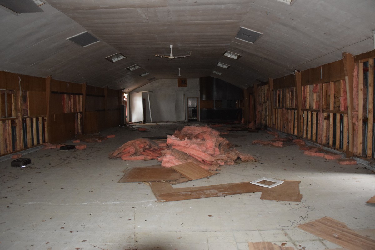
- Combined Mess, May 2021. Photo: Bruce Forsyth.
-

- Combined Mess, May 2021. Photo: Bruce Forsyth.

-

- Combined Mess, May 2021. Photo: Bruce Forsyth.

-

- Combined Mess, May 2021. Photo: Bruce Forsyth.

-

- Combined Mess, May 2021. Photo: Bruce Forsyth.

-

- Combined Mess, May 2021. Photo: Bruce Forsyth.
-

- Combined Mess, May 2021. Photo: Bruce Forsyth.

-

- MSE Section, May 2021. Photo: Bruce Forsyth.

-

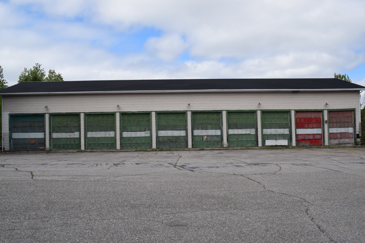
- Fire Hall, May 2021. Photo: Bruce Forsyth.

-

- Looking back towards the main gate. Photo: Bruce Forsyth.

-

- Barracks, May 2021. Photo: Bruce Forsyth.

-

- Barracks, May 2021. Photo: Bruce Forsyth.

-

- Barracks, May 2021. Photo: Bruce Forsyth.

-

- Barracks, May 2021. Photo: Bruce Forsyth.

-

- Barracks, May 2021. Photo: Bruce Forsyth.

-

- Parking lot #3 between the barracks, now just grass, May 2021. Photo: Bruce Forsyth.
-

- Tennis court behind the barracks, May 2021. Photo: Bruce Forsyth.

-

- The remains of the Officers’ barracks, May 2021. Photo: Bruce Forsyth.

-

- Recreation Centre, May 2021. Photo: Bruce Forsyth.

-

- Recreation Centre, May 2021. Photo: Bruce Forsyth.

-

- Recreation Centre, May 2021. Photo: Bruce Forsyth.

-

- Recreation Centre, May 2021. Photo: Bruce Forsyth.
-

- Recreation Centre, May 2021. Photo: Bruce Forsyth.
-

- Recreation Centre, May 2021. Photo: Bruce Forsyth.

-

- Recreation Centre, May 2021. Photo: Bruce Forsyth.

-

- Recreation Centre, May 2021. Photo: Bruce Forsyth.

-

- Jr. Ranks Mess, May 2021. Photo: Bruce Forsyth.

-

- Jr. Ranks Mess, May 2021. Photo: Bruce Forsyth.

-

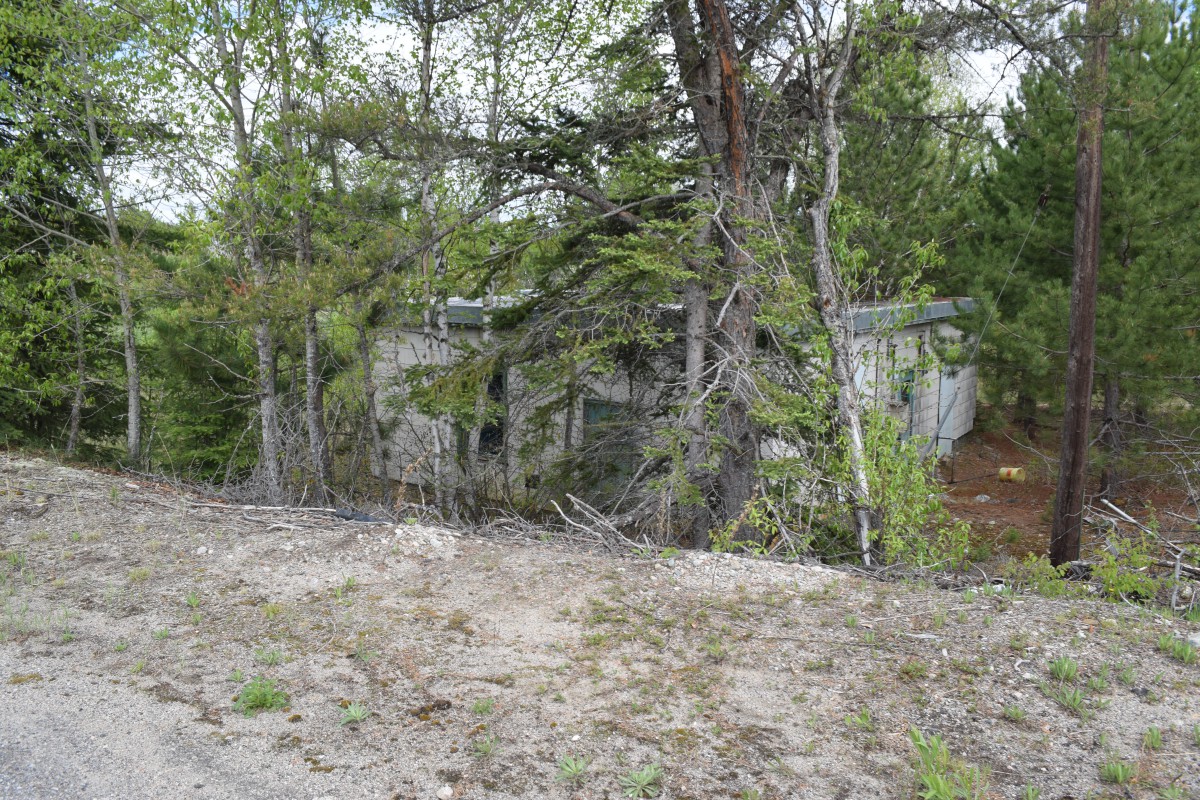
- Collapsed building, May 2021. Photo: Bruce Forsyth.

-

- Collapsed building, May 2021. Photo: Bruce Forsyth.

-

- Collapsed building, May 2021. Photo: Bruce Forsyth.

-

- Collapsed building, May 2021. Photo: Bruce Forsyth.

-

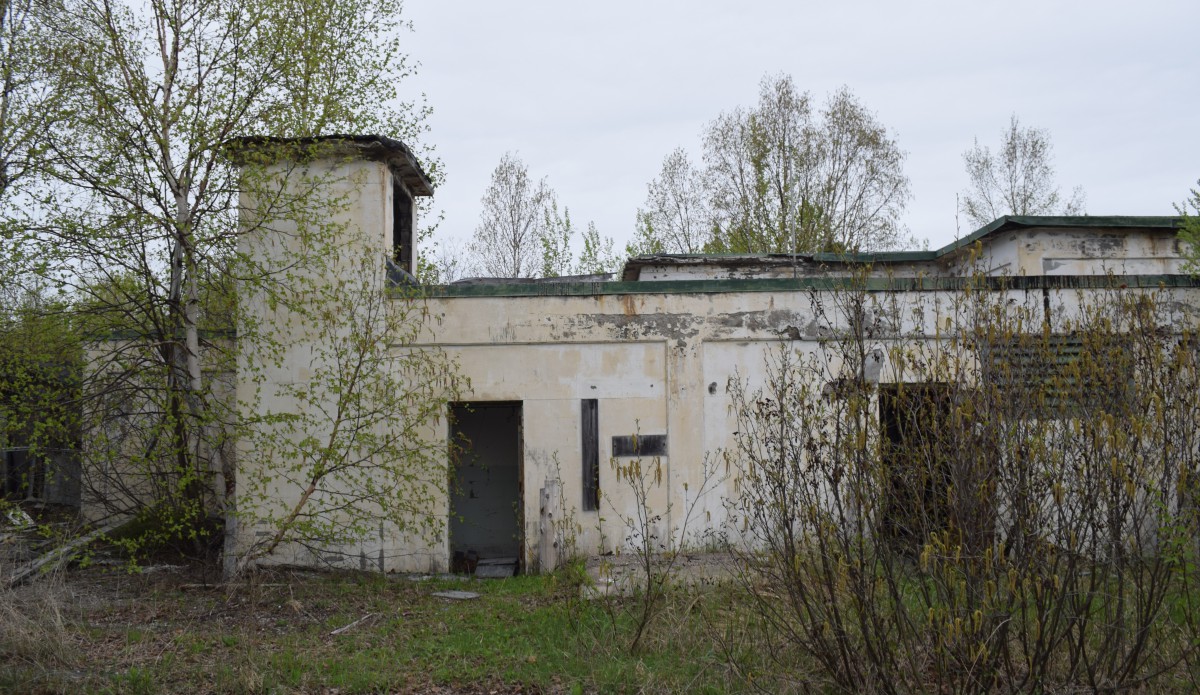
- Gatehouse at the Operations Site, May 2021. Photo: Bruce Forsyth.

-

- Gatehouse at the Operations Site. Photo: Bruce Forsyth.

-

- Gatehouse at the Operations Site. Photo: Bruce Forsyth.

-

- FPS-26 height finder radar tower, May 2021. Photo: Bruce Forsyth.

-

- FPS-26 height finder radar tower, May 2021. Photo: Bruce Forsyth.

-

- FPS-26 height finder radar tower, May 2021. Photo: Bruce Forsyth.

-

- FPS-26 height finder radar tower, May 2021. Photo: Bruce Forsyth.

-

- FPS-26 height finder radar tower, May 2021. Photo: Bruce Forsyth.

-

- May 2021. Photo: Bruce Forsyth.

-

- FPS 27 Search radar tower and the FSQ-47 BUIC computer building, May 2021. Photo: Bruce Forsyth.

-

- Operations building, May 2021. Photo: Bruce Forsyth.
-

- Operations building, May 2021. Photo: Bruce Forsyth.

-

- Operations building, May 2021. Photo: Bruce Forsyth.

-

- Radar tower, May 2021. Photo: Bruce Forsyth.

-

- Radar tower, May 2021. Photo: Bruce Forsyth.

-

- FPS 27 Search radar tower, May 2021. Photo: Bruce Forsyth.

-

- FSQ-47 BUIC computer building, May 2021. Photo: Bruce Forsyth.

-

- FSQ-47 BUIC computer building, May 2021. Photo: Bruce Forsyth.

-

- PMQ trailer park, May 2021. Photo: Bruce Forsyth.

-

- PMQ trailer park, May 2021. Photo: Bruce Forsyth.

-

- One of the old radars, May 2021. Photo: Bruce Forsyth.

Royal Canadian Air Force Station Edgar:
Originally designated No. 204 RCAF Radio Station, RCAF Station Edgar was the southern most station in the Pinetree Line. No. 204 became operational in September 1952 and one month later, the unit was re-designated No. 31 Aircraft Control & Warning Squadron and the station itself RCAF Station Edgar.
Although Pinetree stations were much smaller than full-size bases like Camp Borden, they were still self-contained cities featuring standard military housing & barracks, a school, a recreation centre with a bowling alley & swimming pool, tennis courts, a baseball diamond, an infirmary, a chapel, a firehall, a water treatment & distribution facility, a central heating plant, auto repair shops, cafeteria facilities and sports fields.
All Pinetree stations were equipped with one Search Radar, one Height-Finder Radar and a third back-up radar, and were situated at 150-mile intervals mostly along the 50th parallel, but also down the eastern coast and into southern Ontario and Quebec.
Unlike most Pinetree stations, RCAF Station Edgar also served as a Ground-Control Intercept station in addition to its primary function as an Early Warning Detection station. It was the job of No. 31 AC&W Squadron to track any incoming Soviet threats and then dispatch and direct fighter interceptors to head-off inbound Soviet bombers or missiles.
Overseeing No. 31 AC&W Squadron was No. 3 Air Defence Control Centre, also located at RCAF Station Edgar. No. 3 ADCC also coordinated the operations of No. 32 Squadron at RCAF Station Foymount, No. 33 at RCAF Station Falconbridge, No. 34 at RCAF Station Senneterre and 912th Squadron of and the United States Air Force’ at the Ramore Air Station (later taken over by the RCAF and re-named RCAF Station Ramore). With the creation of the North American Aerospace Defense Command (NORAD) in the late 1950s, No. 3 ADCC was re-designated the Ottawa NORAD Sector Headquarters.
When the Pinetree Line was first established, the RCAF utilized a manual system of plotting the movement of all aircraft on a large plotting board in the Operations Control Centre, situated inside a large reinforced concrete building, with Fighter Control Operators directing this process. In 1961, this system was replaced by the new Semi-Automatic Ground Environment (SAGE) system. A computer now determined the height, speed and direction of enemy targets and relayed the information to the Sector Control Headquarters. This change of operating procedures also lead to No. 31 AC&W Squadron being re-named No. 31 Radar Squadron and RCAF Station Edgar being placed under supervision of the Syracuse NORAD Sector Headquarters.
In May 1963, Ottawa NORAD Sector Headquarters re-located to RCAF Station North Bay and No. 31 Radar Squadron was later put under control of the Detroit Sector.
Continued upgrades in radar equipment lead to greater coverage areas for Pinetree stations. As a result, stations like RCAF Station Edgar were now deemed unnecessary as neighboring RCAF Stations Foymount and Falconbridge were now able to cover Edgar’s area of responsibility. As a result, operations at RCAF Station Edgar were terminated on March 20, 1964 and the station closed at the end of the month. A station disbandment parade was held on 8 April 1964, with the RCAF flag being lowered for the last time.
The Ontario Government purchased the property for just over $218,000 and in 1965, the former station became the Edgar Adult Occupational Centre for handicapped adults. This facility closed in 1999 and the Ontario Realty Corporation put up the property for sale, marketing it for possible industrial or institutional usage.
From 1999 – 2011, the station sat vacant, except for the security guards guarding the property. The Department of National Defence made a return of sorts to Edgar, as various Army Reserve units occasionally utilized the property for training. All of the station’s buildings remained at that time, except for the Operations Control Centre building and the radar towers (they were demolished long ago), but all were slowly deteriorating.
In November 2010, the Township of Oro-Medonte has acquired 42 acres of forested land at the north end of the property for passive recreational and leisure activities.
In July 2011, Developer Miya Consulting purchased the remainder of the property for $2,500 and by the fall of 2011, all the buildings had been demolished, except for the gatehouse, the sewage plant, a pump house near where the long-demolished Operations Building and radar towers once stood, and the chapel. Miya Consulting announced plans to build 82 houses on the property, but the property remains vacant.
In 2017, the gatehouse was burned down by vandals. The chapel and the sewage plant were demolished a few years later.
In March 2021, Miya Consulting began the process of clearing the land for the new housing development.
Additional source Material: the personal recollections of the author (1998-2021), Township of Oro-Medonte media release – http://www.oro-medonte.ca/Newsroom/MediaRelease/index.htm , The Barrie Examiner – http://www.thebarrieexaminer.com/ArticleDisplay.aspx?e=2873236 & Developer buys piece of former Edgar centre, Barrie Examiner, 21 July 2011.
-

- RCAF Station Edgar sign, 1953. Photo: Shirley Askew (Nee Forrest).

-

- Aerial photo of the station. Photo: Unknown.

-

- Aerial photo of the station, from the 1950s. Photo: Unknown.

-

- Battle of Britain Parade, September 1957. Photo: James D Anderson.

-

- Battle of Britain Parade, September 1957. Photo: James D Anderson.

-

- View of the Operations Centre with 2 radomes. Photo: Unknown.

-

- Baseball field with the Combined Mess in the background. October 1959. Photo: Charles Jenkins.

-

- NORAD Sector HQ building, August 1959. Photo Rosemarie Menassas (Nee O’Neill).

-

- Looking down from the operations area towards the barracks in 1964. Photo: Unknown.

-

- Edgar Fire Hall company, 1960. Photo: Larry McKay.

-

- Aerial photo after the RCAF closure, when the property was operating as the Edgar Occupational Centre. Photo: Unknown.
-

- Main gate, March 1997. Photo: Bruce Forsyth.

-

- School with PMQ and the main gate in the background, March 1997. Photo: Bruce Forsyth.

-

- Looking down from the operations area towards the barracks in March 1997. Photo: Bruce Forsyth

-

- Main gate, April 2006. Photo: Bruce Forsyth.

-

- Barracks, April 2006. Photo: Bruce Forsyth.

-

- School, April 2006. Photo: Bruce Forsyth

-

- Chapel and PMQs, April 2006. Photo: Bruce Forsyth.

-

- Combined mess, November 2006. Photo: Bruce Forsyth.

-

- Soldiers from the Grey & Simcoe Foresters during Exercise Cougar Spirit One with the Recreation Centre to the right and the Administration Building to the right, 4 Nov 2006. Photo: Bruce Forsyth.

-

- Soldiers from the Grey & Simcoe Foresters during Exercise Cougar Spirit One with the Vocational Workshops to the right and the Highview Administration Building in the background, 4 Nov 2006. Photo: Bruce Forsyth.

-

- Station map, November 2006. Photo: Bruce Forsyth.

-

- Interior of barracks. Photo: Bruce Forsyth.

-

- After demolition of the station buildings, April 2012. Photo: Bruce Forsyth.

-

- The lone guardhouse, one of only three buildings that remain, September 2014. Photo: Bruce Forsyth.

-

- The empty streets leading up to the Chapel, one of the few remaining buildings, September 2014. Photo: Bruce Forsyth.

-

- Plaque from the Protestant Chapel, now hanging in the Base Borden Military Museum, April 2014. Photo: Bruce Forsyth

-

- The remains of the guardhouse, May 2017. Photo: Bruce Forsyth.

-

- The remains of the guardhouse, May 2017. Photo: Bruce Forsyth.

-

- The remains of the guardhouse, May 2017. Photo: Bruce Forsyth.

-

- The Combined Chapel, May 2017. Photo: Bruce Forsyth.

-

- Looking from the Combined Chapel back to the main gate, May 2017. Photo: Bruce Forsyth.

-

- Interior of the Combined Chapel, May 2017. Photo: Bruce Forsyth.

-

- Interior of the Combined Chapel, May 2017. Photo: Bruce Forsyth.

-

- Interior of the Combined Chapel, May 2017. Photo: Bruce Forsyth.

-

- Interior of the Combined Chapel, May 2017. Photo: Bruce Forsyth.

-

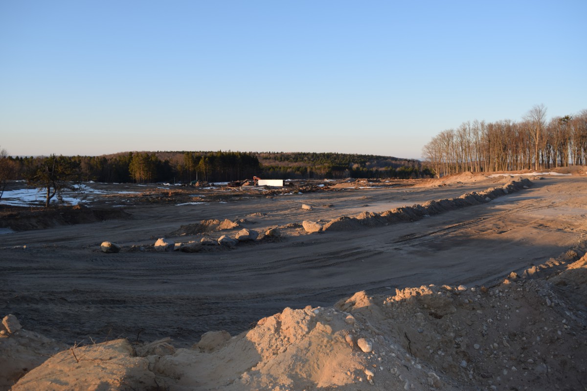
- The land being cleared for a housing development, March 2021. Photo: Bruce Forsyth.

-

- The land being cleared for a housing development, March 2021. Photo: Bruce Forsyth.

-

- The land being cleared for a housing development, March 2021. Photo: Bruce Forsyth.

-

- Rubble from a demolished building, near where the fire hall used to stand, March 2021. Photo: Bruce Forsyth.

-

- March 2021. Photo: Bruce Forsyth.
-

- March 2021. Photo: Bruce Forsyth.

-

- Old iron pipe, March 2021. Photo: Bruce Forsyth.

-

- Rubble from a demolished building, near where the station HQ once stood, March 2021. Photo: Bruce Forsyth.

-

- The old tennis court, March 2021. Photo: Bruce Forsyth.

-

- An old iron pipe sticking out of the ground, with a pumphouse in the background, March 2021. Photo: Bruce Forsyth.

-

- Pumphouse where the long-demolished Operations Building once stood, March 2021. Photo: Bruce Forsyth.

-

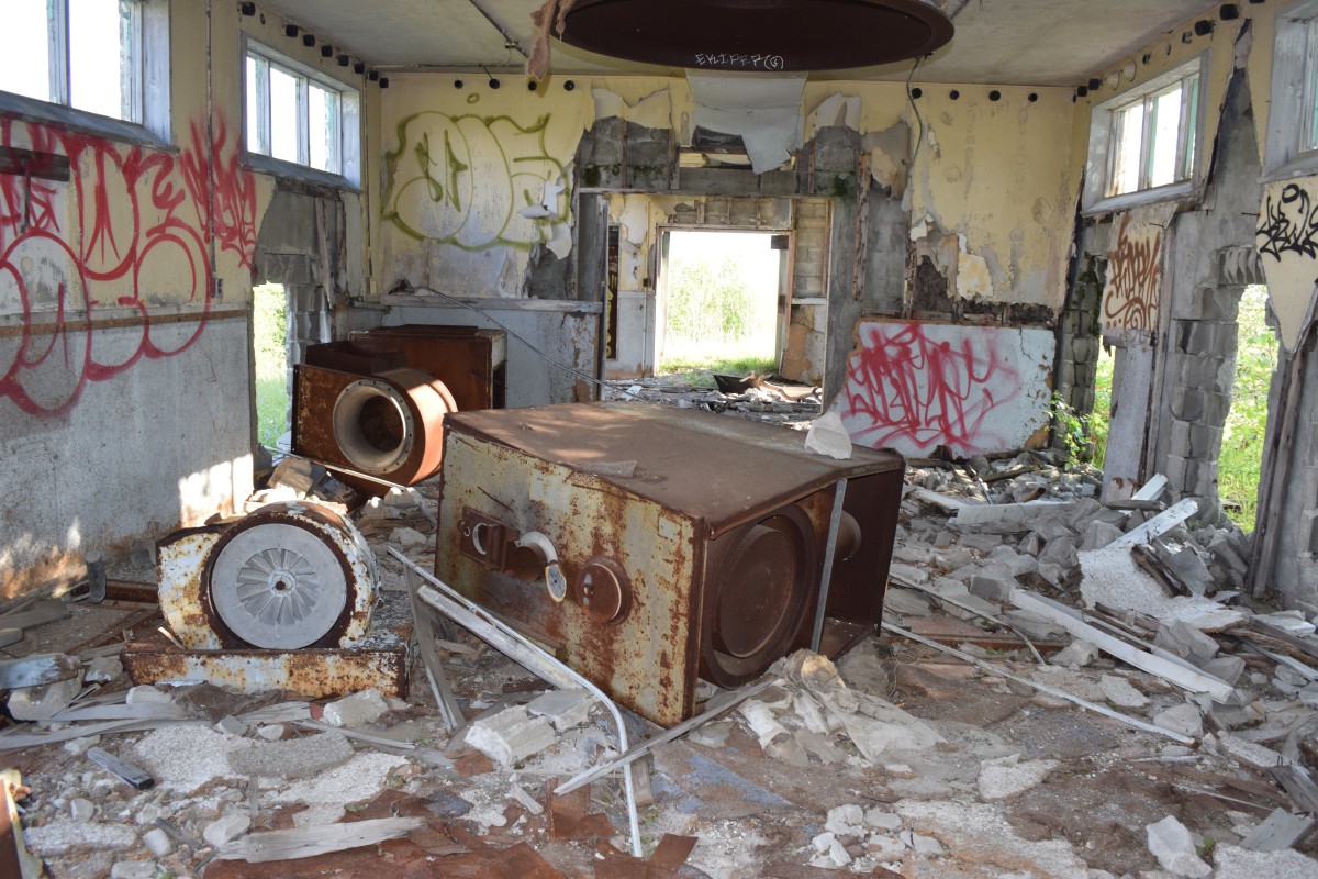
- Inside the pumphouse, March 2021. Photo: Bruce Forsyth.

-

- Inside the pumphouse, March 2021. Photo: Bruce Forsyth.

-

- Inside the pumphouse, March 2021. Photo: Bruce Forsyth.

-

- Inside the pumphouse, March 2021. Photo: Bruce Forsyth.

-

- Looking out from the pumphouse, across the station property and down towards the main gate, March 2021. Photo: Bruce Forsyth.

-

- Sewer cover dated 1950, March 2021. Photo: Bruce Forsyth.

-

- Edgar main gate, October 2024. Photo: Bruce Forsyth.

-

- Edgar’s main road from the main gate is now Pinetree Drive, October 2024. Photo: Bruce Forsyth.

-

- Edgar, looking towards where chapel was, from the main gate, October 2024. Photo: Bruce Forsyth.

-

- Edgar, October 2024. Photo: Bruce Forsyth.

Canadian Forces Station Falconbridge:
Opened in 1952 as RCAF Station Falconbridge, with the radar functions being run by No. 33 Aircraft Control & Warning Squadron.
Falconbridge, like many other similar facilities was a fully self-contained community. In addition to shared quarters, the station included 101 PMQs, some of them trailers, water and sewage facilities, a school, library, church, an infirmary, and a slew of recreational facilities including a bowling alley, recreational hall, gymnasium, sauna and children’s wading pool. A post office operated from 1955 to 1960.
Following the Unification, the station was re-named CFS Falconbridge.
During the 1970s, Falconbridge also became as a training facility, specializing in basic and advanced instruction of Air Defence Technicians’ courses. Following the closure of CFS Foymont in 1974, Falconbridge expanded it’s area of responsibility.
Falconbridge was also home to a training school, a Detachment of the Air Weapons Control and Countermeasures School from CFB North Bay, opened at the station in 1975.
On 11 November 1975, CFS Falconbridge became involved in tracking what many believed to be a UFO. Two U.S. Air Force F-106 jet fighters were dispatched to the scene, along with Air National Guard and Strategic Air Command helicopters, but none was ever able to make a positive identification.
In 1985, DND announced that the Pinetree Line would be shut down as a part of the North American Air Defence Modernization Plan. As a result, CFS Falconbridge ceased operations and closed in 1986. The RCAF departed and the station was put up for sale.
Appraised between $1.3 and $1.6 million based on potential rental income from the 97 PMQs, the property was essentially a complete town featuring all the same amenities of the other Pinetree stations, including a library, recreational building with snack bar, theatre, bowling alley, sauna, medical building, school, church, garage, office building, barracks that could be turned into apartments, the combined mess with kitchens and social areas, pump station, driving range, soccer field, two ball parks, ski tow and downhill ski area and a football field.
General Leaseholds won the bid for a paltry $140,000, generating much controversy for the low sale price. The controversy escalated when the property was sold shortly afterwards to a local trailer park owner, Henry Shepherd for $190,000, only to sell it in 1988 for well over a million to Pine Ridge Developments.
Pine Ridge Developments began renting out the former PMQs as private residences.
The radomes were removed but the radar towers and the operations centre remained as did all the other station buildings.
Some of the buildings were rented out, but the remainder of the buildings were allowed to deteriorate. By 2003, Pine Ridge Development were the subject of criticism for making only minimal safety improvements to the base’s badly deteriorated former barracks and mess hall despite having rented out homes on the site to tenants with children. The sports field, park and playground slowly became overgrown.
In 2007, the property was purchased by Kona Management, who immediately began the process of making improvements to the property. The homes were improved and the deteriorated buildings sealed up to prevent intrusion. Most were turned into rental storage buildings. The operations centre and the remains of the radar towers were demolished in 2007.
As with a lot of the former Pinetree Line stations, neglect and ambivalence have hampered the opportunity to turn the remains of CFS Falconbridge into a viable and lucrative self-sustaining community and industrial park.
Additional sources: www.ghosttownpix.com/ontario/towns/falconbridge.html, https://www.sudbury.com/local-news/radar-base-no-bargain-for-tenants-206289.
-

- LACs Gord Fox and Floyd Newell in front of Rec Hall, February 1954. Photo: Joe Milner.

-

- Operations site, with the domestic site in the background, 1958. Photo: Terry Pineau.

-

- Operations and domestic site, May 1960. Photo: Joe Simard.

-

- Domestic site. DND diagram.

-

- Operations site. DND diagram.

-

- Operations building one of the radar towers as seen from the foundation of the gatehouse, July 2002. Photo: Bruce Forsyth.

-

- Operations building with 2 of the radar towers, July 2002. Photo: Bruce Forsyth.

-

- The third radar tower, July 2002. Photo: Bruce Forsyth.

-

- Station chapel, July 2002. Photo: Bruce Forsyth.

-

- Combined mess, July 2002. Photo: Bruce Forsyth.

-

- Long shot off combined mess, barracks and social building, July 2002. Photo: Bruce Forsyth.

-

- Interior of officers’ / transient barracks at the former RCAF Station Falconbridge, Ontario, July 2002. Photo: Bruce Forsyth

-

- Officers’ / Transient barracks, July 2002. Photo: Bruce Forsyth.

-

- Officers’ / Transient barracks, July 2002. Photo: Bruce Forsyth.

-

- Recreation Centre and canteen, July 2002. Photo: Bruce Forsyth

-

- Recreation Centre and canteen, July 2002. Photo: Bruce Forsyth.

-

- MSE buildings in the foreground and the Operations Centre on the hill as seen from the main road, July 2002. Photo: Bruce Forsyth.

-

- Main gate of the station, now owned by Pine Ridge Developments, July 2002. Photo: Bruce Forsyth.

-

- Recreation Centre and canteen, July 2012. Photo: Bruce Forsyth.

-

- Recreation Centre, August 2018. Photo: Google Maps.

-

- Officers’ / Transient barracks, July 2012. Photo: Bruce Forsyth.

-

- Combined mess and social building, July 2012. Photo: Bruce Forsyth.

-

- PMQ, still in use as a private residence, July 2012. Photo: Bruce Forsyth.

-

- Main gate, July 2021. Photo: Bruce Forsyth.

-

- Station school, July 2021. Photo: Bruce Forsyth

-

- Road leading to the Operations site, July 2021. Photo: Bruce Forsyth

-

- The remains of the gate house for the Operations site can barely be seen in the trees and vegetation in July 2021. Compare with photo from July 2002 Photo: Bruce Forsyth..

-

- Pumphouse for the Operations site, July 2021. Photo: Bruce Forsyth

-

- Fuel tank at the Operations site, July 2021. Photo: Bruce Forsyth

-

- Transmitter building, July 2021. Photo: Bruce Forsyth

-

- Transmitter building, July 2021. Photo: Bruce Forsyth
-

- Transmitter building, July 2021. Photo: Bruce Forsyth

-

- Where the Operations Building once stood in July 2021. Compare with photo from July 2002 Photo: Bruce Forsyth.

-

- Foundation of the Operations Building, July 2021. Photo: Bruce Forsyth

-

- Foundation of the Operations Building, July 2021. Photo: Bruce Forsyth

-

- Remains of one of the radar towers, July 2021. Photo: Bruce Forsyth.

-

- PMQ, July 2021. Photo: Bruce Forsyth

-

- PMQs, July 2021. Photo: Bruce Forsyth

-

- PMQs, July 2021. Photo: Bruce Forsyth

-

- GATR Site, near the Sudbury Airport, July 2021. Photo: Bruce Forsyth

-

- Photo: Sintinel magazine.

-

- Photo: Sintinel magazine.

Canadian Forces Station Foymount:
Opened in 1952 as RCAF Station Foymount, with the radar functions being run by No. 32 Aircraft Control & Warning Squadron.
The radar itself was situated at the top of a 523 metre hill, one of the highest points in southern Ontario. The main lodger unit was No. 32 Aircraft Control and Warning Squadron, later renamed No. 32 Radar Squadron when the Semi Automatic Ground Environment system was implemented in 1961.
In 1967, RCAF Station Foymount was renamed CFS Foymount with the unification of the Canadian Forces. By the early 1970s, the base became redundant as radars at CFS Falconbridge and CFS Lac St. Denis were deemed sufficiently powerful to monitor Foymount’s coverage area.
The station shut down their radars on 1 April 1973 and closed six months later on 1 October.
The former station is now a commercial-residential complex and most of the buildings remain and in use.
The PMQ homes are private residences, but 3 apartment-style residences are vacant and deteriorating.
The operations centre was demolished years ago, leaving only the concrete pilings that once supported enclosed walkways between the operations buildings and the radar towers.
The GATR site was located on Highway 515, on the west side of the road, two miles south of the intersection of Highway 516. Only the building foundation remains.
Additional source: https://campingcdn.blogspot.com/2013/05/a-cfs-foymount-gatr-site.html
-

- Airmens’ Barracks, Sept 2014. Photo: Bruce Forsyth.

-

- Airwomens’ Barracks, Sept 2014. Photo: Bruce Forsyth.

-

- Sept 2014. Photo: Bruce Forsyth.

-

- Firehall, Sept 2014. Photo: Bruce Forsyth.

-

- Sept 2014. Photo: Bruce Forsyth.

-

- Sept 2014. Photo: Bruce Forsyth.

-

- Apartments, Sept 2014. Photo: Bruce Forsyth.

-

- Combined Mess, Sept 2014. Photo: Bruce Forsyth.

-

- PMQs, now private residences, Sept 2014. Photo: Bruce Forsyth.

-

- PMQs, now private residences, Sept 2003. Photo: Bruce Forsyth.

-

- Main gate, Sept 2003. Photo: Bruce Forsyth.

-

- School, Sept 2003. Photo: Bruce Forsyth.

-

- Station HQ, Sept 2003. Photo: Bruce Forsyth.

-

- Road leading to the operations area, Sept 2003. Photo: Bruce Forsyth.

-

- Former location of operations building, Sept 2003. Photo: Bruce Forsyth.

-

- Former location of operations building, Sept 2003. Photo: Bruce Forsyth.

-

- Concrete pilings that once supported one of the radar towers, Sept 2003. Photo: Bruce Forsyth.

-

- Concrete pilings that once supported enclosed walkways between the operations building and the radar towers, Sept 2003. Photo: Bruce Forsyth.

-

- Foymount, 1973. Photo: Unknown.

-

- Station map, RCAF Station Foymount.

-

- Transmitter building, April 2022. Photo: Ryan Kennedy.

-

- Transmitter building, April 2022. Photo: Ryan Kennedy.

-

- Transmitter building, April 2022. Photo: Ryan Kennedy.

-

- Transmitter building, April 2022. Photo: Ryan Kennedy.

-

- Transmitter building, April 2022. Photo: Ryan Kennedy.

-

- Transmitter building, April 2022. Photo: Ryan Kennedy.

-

- Transmitter building, April 2022. Photo: Ryan Kennedy.

-

- Entrance to the GATR site, September 2022. Photo: Bruce Forsyth.

-

- A new cabin built atop the foundation of the GATR building, September 2022. Photo: Bruce Forsyth.

-

- A new cabin built atop the foundation of the GATR building, September 2022. Photo: Bruce Forsyth.

Canadian Forces Station Lowther:
Opened in 1957 as Lowther Air Station of the United States Air Force, with the radar functions being run by No. 639 Aircraft Control & Warning Squadron.
In March 1963, Lowther AS was connected to the Semi-Automatic Ground Environment (SAGE) system and the station became a long-range radar site.
On 1 July 1963, the station was turned over to the RCAF, the final Pinetree Line site to be transferred. Under RCAF jurisdiction, the station was renamed RCAF Station Lowther, with No. 36 Radar Squadron as the operating unit. This was part of an arrangement with the United States that came as a result of the cancellation of the Avro Arrow. Canada would lease 66 F-101 Voodoo fighters and take over operation of 12 Pinetree radar bases.
In 1985, DND announced that the Pinetree Line would be shut down as a part of the North American Air Defence Modernization Plan. As a result, CFS Lowther closed on 1 April 1987.
All that remains of remains CFS Lowther today are the abandoned roadways and building foundations.
The old gymnasium had been moved approximately 6 kilometres to the east to the nearby town of Opasatika where it was turned into Opasatika Mushroom farm. The GATR site building is still standing and the property was taken over by Hyundai for use as a winter test facility.
As a memorial an AN/FPS-26 Height Finder antenna was relocated to the main throughway in Kapuskasing, where the many children who lived on base went to school and the majority of the families shopped and carried out other business.
-

- Lowther Air Station, USAF. Historical photo.

-

- Lowther, 1984. Nothing remains today. Photo: Brian McNair.

-

- Base map.

-

- CFS Lowther taken from Highway 11, two years after closure, June 1989. Photo Courtesy of Roy Morley.

-

- CFS Lowther, July 1984. Photo: Brian McNair.

-

- GATR site, July 1984. Photo: Brian McNair.

-

- Entrance to the former station, May 2021. Photo: Bruce Forsyth.

-

- Looking into where the domestic site was located, with the access road to the right, May 2021. Photo: Bruce Forsyth.

-

- The former Recreation Centre, now a few miles east of the station site, May 2021. Photo: Bruce Forsyth.

-

- GATR site, May 2021. Photo: Bruce Forsyth.
-

- GATR site, May 2021. Photo: Bruce Forsyth.

-

- GATR site, May 2021. Photo: Bruce Forsyth.

-

- GATR site, May 2021. Photo: Bruce Forsyth.

-

- GATR site, May 2021. Photo: Bruce Forsyth.

-

- AN/FPS-26 Height Finder antenna in Kapuskasing. Photo: Bruce Forsyth.

-

- Photo: Bruce Forsyth.

-

- Only roads and foundations can be found today. Photo: Google Maps.

Additional sources: Google Maps.
Canadian Forces Station Moosonee:
Opened in 1961 as RCAF Station Moosonee, with the radar functions being run by No. 15 Aircraft Control & Warning Squadron.
In 1967, RCAF Station Moosonee was renamed CFS Moosonee with the Unification of the Forces.
By 1975, advances in radar technology made the station redundant, and it was subsequently closed, as other stations could handle its area of responsibility. Some buildings were used by the Town after the closure, including the base swimming pool and recreation centre.
Parts of the station remain in use as the Northern Lights Secondary School, with the PMQs serving as housing.
-

- Barracks, March 2005. Photo: Paul Lantz.

-

- Buildings in use by the Public Works Deptment. March 2005. Photo: Paul Lantz.

-

- Barracks on Keewatin Drive, May 2000. Photo: Dan Anthony.

-

- Combined Mess, with the search radar tower seen in the background., May 2000. Photo: Dan Anthony.

-

- Combined Mess, May 2000. Photo: Dan Anthony.

-

- Concrete foundation at the TACAN site. There is still a lot of barbed wire remaining which has been grown over by the forest, May 2000. Photo: Dan Anthony.

-

- The main guard house (Bay Road entrance). All that remains is the concrete. The Combined Mess, some barracks and the search radar tower can be seen in the background. Photo: Dan Anthony.

-

- Motor Transport area looking east towards the search and height finder radar towers, May 2000. Photo: Dan Anthony.
-

- Various buildings, August 2000. Photo: Christopher Palmer.

-

- Panoramic view of CFS Moosonee taken from top deck of Search tower, April 1975. Photo: Hays Brown.

-

- Row of PMQs, June 1973. Photo: Dianne Callaghan (Carr).

-

- Aerial photo of the radar station,14 August 1962. Photo: Air Defence Museum.

-

- Air Force Policeman Ralph Purcell. Photo: Ralph Purcell.

-

- Commissionaire at the main gate, May 1962. Photo: Ralph Purcell.

-

- the Guard House with the Headquarter’s building, the Combined Mess and barracks in view, May 1962. Photo: Ralph Purcell.

Royal Canadian Air Force Station Pagwa:
Opened in 1953 as Pagwa Air Station of the United States Air Force, with the radar functions being run by No. 913 Aircraft Control & Warning Squadron.
Control of the station was transferred to the RCAF on 29 May 1963 and the station was re-named RCAF Station Pagwa. This was part of an arrangement with the United States that came as a result of the cancellation of the Avro Arrow that saw Canada lease 66 F-101 Voodoo fighters and take over operation of 12 Pinetree radar bases.
Also in 1963, Pagwa was upgraded to the Semi-Automatic Ground Environment (SAGE) system and the station became a long-range radar site.
The radar squadron was disbanded on 1 October 1966. The last RCAF personnel left the station on 15 December 1966 bringing to a close one of the shortest, in time, RCAF manned site in the NORAD system.
All that remains are building foundations and the roadways.
-

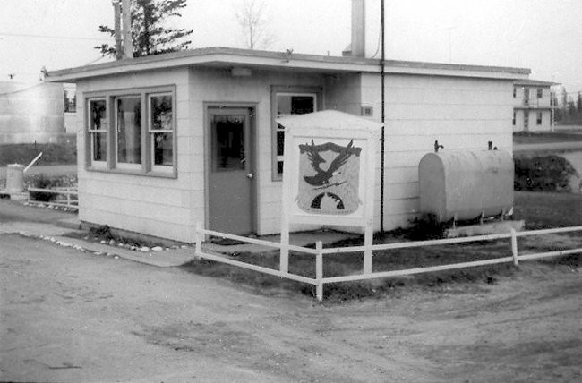
- Main gate, 1960. Photo: Paul Krepp.

-

- Operations building, 1960. Photo: Paul Krepp.

-

- Barrack blocks, 1960. Photo: Paul Krepp.

-

- Aerial photo, 1962. Photo: Richard E Small

-

- Handover ceremony from USAF to RCAF, 29 May 1963. Photo: Dick Walters

-

- USAF Airmen Ron Gustafson and Hoot Gibson in front of the barracks, March 1955. Photo: Ron Gustafson.

-

- USAF NCO Club, November 1961. Photo: Richard E. Small.

-

- Ron Thompson in front of Operations site, May 1963. Photo: Dick Walters.

-

- Sign at the main gate before the handover from USAF to RCAF, May 1963. Photo: Bud Holgate.
-

- (L-R) Ron Thompson, Dick Walters, Warren Carr in front of barracks, May 1963. Photo: Dick Walters.

-

- Handover to new CO at Pagwa, September 1965. (L-R) S/L Bredahl (new CO at Pagwa), W/C LM Pederson (CO Armstrong), F/O Brennan (CAdO), F/O CA Sanderson (CAdO Armstrong), F/O Rene Cyr (SCEO), F/O Robert Rockburn (SAO), F/L Chuck Maybee (CGEO), F/L Frank Thibodeau (SlogO). Photo: Robert Rockburn.

-

- Aerial view of Pagwa station, August 1965. Photo: Robert Rockburn

-

- Main entrance, June 2002. Photo: Richard Cameron.

-

- Gatehouse foundation, June 2002. Photo: Richard Cameron.

-

- Foundation, June 2002. Photo: Richard Cameron.

-

- Barracks foundation, June 2002. Photo: Richard Cameron.

-

- Barracks foundation, June 2002. Photo: Richard Cameron.

-

- Foundation of the combined mess, June 2002. Photo: Richard Cameron.

-

- Foundation of the MSE garage., June 2002. Photo: Richard Cameron.

-

- Remains of one of the radar towers, June 2002. Photo: Richard Cameron.


-

- Aerial photo, present day. Photo: Google Maps.

-

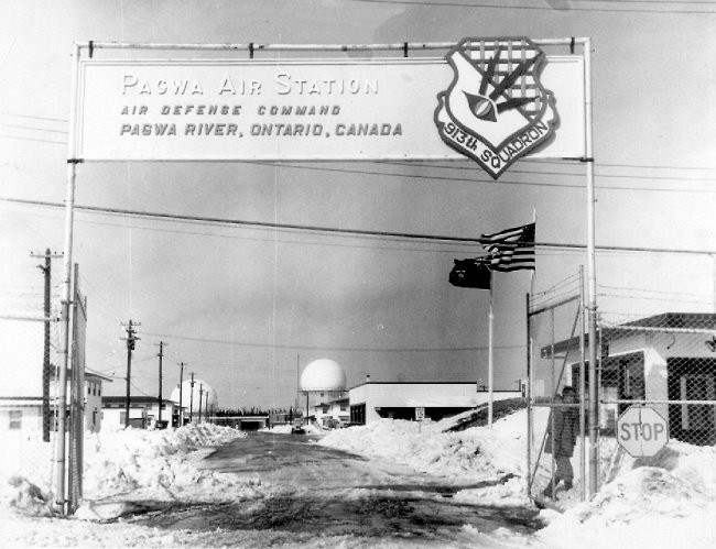
- Aerial view of Pagwa station. Historical photo.

Canadian Forces Station Ramore:
Opened in 1953 as Ramore Air Station of the United States Air Force. The base station was manned by members of the USAF 912th Aircraft Control and Warning Squadron.
Ramore was also used as a relay station for the newly established Mid-Canada Line, between the Sector Control Site at RCAF Station Winisk and Regiona Control Centre at RCAF Station North Bay. A large parabolic antenna was installed nearby at Mount Kempis.
In early 1962, operation of the station was transferred to the RCAF as part of an arrangement with the United States that came as a result of the cancellation of the Avro Arrow. Canada would lease 66 F-101 Voodoo fighters and take over operation of 12 USAF Pinetree radar stations including Ramore.
The station was renamed the site RCAF Station Ramore, with No. 35 Aircraft Control & Warning Squadron taking over the radar functions.
The relay functions at Ramore ceased when the Mid-Canada Line shut down in 1965.
With the Unification of the Forces, the station was re-named CFS Ramore on 10 August 1967.
Advances in radar technology made Ramore redundant, as CFS Lowther and CFS Senneterre were now able to cover the area that Ramore had previously monitored. As a result, CFS Ramore closed on 1 April 1974.
In 1975, the station was sold to the Black River-Matheson Township for $100,000, who operated the Lava Mountain Lodge at the former station for several years before closing.
The part of the domestic site, including the former PMQ area, is now a trailer campground. None of the trailer-style PMQs remain today, nor does The Ponderosa building beside the lake.
Today, only a handful of buildings remain, ranging from badly deteriorated to falling down and slowly being consumed by vegetation. Only the MSE nine-bay garage appears to still be in use. The foundations of several buildings also dot the property.
The plotting room section of the operations building remains, along with one of the radar towers and several foundations at the top of Lava Mountain.
Two of the radar antennas were donated to the Military Communications and Electronics Museum at the 4th Canadian Division Support Base Kingston.
-

- Aerial of operations area, 1962. Photo: Department of Energy, Mines and Resources.

-

- Aerial of domestic area, 1962. Photo: Department of Energy, Mines and Resources.

-

- Gatehouse at the main gate of Ramore Air Station, May 1959. Photo: Ren L’Ecuyer.
-

- Gatehouse, July 2018. Photo: Bruce Forsyth.

-

- Gatehouse at the former RCAF Station Ramore, Ontario, a former Cold War radar station, July 2018. Photo: Bruce Forsyth.

-

- Interior of the gatehouse, July 2018. Photo: Bruce Forsyth

-

- Pump house, July 2018. Photo: Bruce Forsyth.

-

- Central Heating Plant, July 2018. Photo: Bruce Forsyth.

-

- Central Heating Plant, July 2018. Photo: Bruce Forsyth.

-

- Interior of pump house, July 2018. Photo: Bruce Forsyth.

-

- Interior of the Central Heating Plant, July 2018. Photo: Bruce Forsyth.

-

- Interior of the Central Heating Plant, July 2018. Photo: Bruce Forsyth.

-

- Four-bay garage in the Motor Support Equipment area,, July 2018. Photo: Bruce Forsyth.

-

- Nine-bay garage in the Motor Support Equipment area,, July 2018. Photo: Bruce Forsyth.

-

- Sole remaining radar tower, July 2018. Photo: Bruce Forsyth.

-

- Interior of the remaining radar tower, July 2018. Photo: Bruce Forsyth.

-

- Operations Building, July 2018. Photo: Bruce Forsyth.

-

- Demolished portion of the Operations Building, July 2018. Photo: Bruce Forsyth.

-

- Demolished portion of the Operations Building, July 2018. Photo: Bruce Forsyth.

-

- Foundation of one of the radar towers, July 2018. Photo: Bruce Forsyth.

-

- Demolished portion of the Operations Building with the sole remaining radar tower in the background, July 2018. Photo: Bruce Forsyth.

-

- Hallway in the Operations Building, July 2018. Photo: Bruce Forsyth.

-

- Plotting room in the Operations Building, July 2018. Photo: Bruce Forsyth.

-

- Plotting room in the Operations Building, July 2018. Photo: Bruce Forsyth.

-

- The Heads in the Operations Building, July 2018. Photo: Bruce Forsyth.

-

- Road leading to the Operations site, July 2018. Photo: Bruce Forsyth.

-

- Radar units from Ramore, now at the Communications and Electronics Museum at 4th Canadian Division Support Base Kingston, May 2012. Photo: Bruce Forsyth.

-

- Collapsed building in the domestic area, July 2018. Photo: Bruce Forsyth.

-

- Building in the domestic area, July 2018. Photo: Bruce Forsyth.

-

- Interior of the previous building in the domestic area, July 2018. Photo: Bruce Forsyth.

-

- Collapsed building in the domestic area, July 2018. Photo: Bruce Forsyth.

-

- Supply Building, July 2018. Photo: Bruce Forsyth.

-

- Interior of the Supply Building, July 2018. Photo: Bruce Forsyth.

-

- Interior of the Supply Building, July 2018. Photo: Bruce Forsyth.

-

- Interior of the Supply Building, July 2018. Photo: Bruce Forsyth.

-

- Interior of the Supply Building, July 2018. Photo: Bruce Forsyth.

-

- Foundation of one of the barracks, July 2018. Photo: Bruce Forsyth.

-

- Foundation of one of the barracks, July 2018. Photo: Bruce Forsyth.

-

- Looking across the domestic site. Barracks foundation in foreground, the Central Heating Plant between the pine trees, with the former location of the Administration building beside it, July 2018. Photo: Bruce Forsyth.

-

- Building being consumed by vegetation, July 2018. Photo: Bruce Forsyth.

-

- Crumbling building in the PMQ area, July 2018. Photo: Bruce Forsyth.

-

- Interior of a crumbling building in the military housing area, July 2018. Photo: Bruce Forsyth.

-

- Sports field, July 2018. Photo: Bruce Forsyth.

-

- Foundation of The Ponderosa in the PMQ area, July 2018. Photo: Bruce Forsyth.

-

- Foundation of The Ponderosa in the PMQ area, July 2018. Photo: Bruce Forsyth.

-

- Interior of the Power plant on The Hill, 2014. Photo: Bree Allan

-

- Interior view of the Power Plant on the hill, August 2002. Photo: Ralph Gronlund.

Additional source material: the personal recollections of the author (2018), Wikipedia, The Legend of Lava Mountain – http://www.flickr.com/photos/axle81401/sets/72157618431328105/
Canadian Forces Station Sioux Lookout:
Opened in 1952 as Sioux Lookout Air Station of the United States Air Force, with the radar functions being run by No. 912 Aircraft Control & Warning Squadron.
The station was turned over to the RCAF on 1 October 1962. The operating unit was re-designated 39 Aircraft Control and Warning Squadron and the base, RCAF Station Sioux Lookout. This was part of an arrangement with the United States that came as a result of the cancellation of the Avro Arrow. Canada would lease 66 F-101 Voodoo fighters and take over operation of 12 Pinetree radar bases.
In 1963, was upgraded to the Semi-Automatic Ground Environment (SAGE) system and became a long-range radar site. The station was assigned to the 30th NORAD Region. As a consequence of the change, the operating unit was once again renamed, this time as 39 Radar Squadron.
In 1966, Sioux Lookout was reassigned to the 29th NORAD Region, and in October 1967, Sioux Lookout was re-named CFS Sioux Lookout in accordance with the Unification of the Forces.
In 1969, Sioux Lookout was again switched to the 23d NORAD Region and in 1983 it began reporting to Canada West ROCC.
In 1985, DND announced that the Pinetree Line would be shut down as a part of the North American Air Defence Modernization Plan. As a result, CFS Sioux Lookout closed in July 1987.
Most of the station’s buildings remain, including the operations site. The property is now privately owned. The property owner lives in one of the old barracks.
Additional source material: information provided by Michelle Hrynchuk, current property owner (2013).
-

- USAF helicopter landing in the domestic site, October 1955. Photo: Don Cronwell.

-

- Station sign, November 1963. Photo: Neil Thibedeau.

-

- Aerial of the entire station, 1970. Photo Sioux Lookout 25th Anniversary Yearbook.

-

- Operations site, 1970. Photo: Sioux Lookout 25th Anniversary Yearbook.

-

- Pinetree Trailer Court in Sioux Lookout, October 1971. Sioux Lookout Bulletin.

-

- Base security exercise with the Canadian Airborne Regiment as the enemy force, 1983. Sentinel magazine.

-

- Base security exercise with the Canadian Airborne Regiment as the enemy force, 1983. Sentinel magazine.

-

- Inside one of the Radomes, 1983. Sentinel magazine.

-

- Remains of guardhouse at main gate, entering the station, August 1999. Photo: Fred Southwell.

-

- Front entrance to the combined mess, August 1999. Photo: Fred Southwell.

-

- Remains of barracks, August 1999. Photo: Fred Southwell.

-

- Junior Ranks Club, August 1999. Photo: Fred Southwell.

-

- Satelite photo of the entire station. Photo: Google Maps.

-

- Close-up of the domestic area. Photo: Google Maps.

-

- Close-up of the operation site. Photo: Google Maps.

-

- Recreation Centre, August 1999. Photo: Fred Southwell.

-

- Sage Operations Building, August 1999. Photo: Fred Southwell.

-

- Power Plant, August 1999. Photo: Fred Southwell.

-

- Interior of the Power Plant, August 1999. Photo: Fred Southwell.

-

- Guard house, May 1989. Photo: Courtesy of Patrick Carstens.

-

- Barracks, May 1989. Photo: Courtesy of Patrick Carstens.

-

- Barracks, May 1989. Photo Courtesy of Patrick Carstens.

-

- Barracks and Headquarters building, May 1989. Photo: Courtesy of Patrick Carstens.

-

- Barracks and Junior Ranks Mess, May 1989. Photo: Courtesy of Patrick Carstens.

-

- Barracks, May 1989. Photo Courtesy of Patrick Carstens.

-

- Curling Club, May 1989. Photo: Courtesy of Patrick Carstens.

-

- MSE building, May 1989. Photo: Courtesy of Patrick Carstens.

-

- Radar tower, May 1989. Photo: Courtesy of Patrick Carstens.

-

- Operations site, March 1987. Photo: Courtesy Frank Butcher.

-

- Power plant, May 1989. Photo: Courtesy of Patrick Carstens.

-

- GATR building, May 1989. Photo: Courtesy of Patrick Carstens.

-

- RCAF Station Sioux Lookout, December 1965. Photo: Courtesy of LAC Eric Williams.

-

- RCAF Station Sioux Lookout, fire south-west of the station, 3 June 1967. Photo: Courtesy of LAC Eric Williams.

-

- An FPS-6 Height-Finder radar antenna in a small parkette in Sioux Lookout. Photo: Google Maps.

-
- Looking down the road to the main entrance, May 2021. Photo: Bruce Forsyth.

-

- Gatehouse, May 2021. Photo: Bruce Forsyth.

-

- Gatehouse, May 2021. Photo: Bruce Forsyth.

-

- 10 Bay MSE Garage, May 2021. Photo: Bruce Forsyth.
-

- MSE building, May 2021. Photo: Bruce Forsyth.

-

- May 2021. Photo: Bruce Forsyth.

-

- Pumphouse, May 2021. Photo: Bruce Forsyth.
-

- Combined Mess, May 2021. Photo: Bruce Forsyth.

-

- Barracks, May 2021. Photo: Bruce Forsyth.

-

- Barracks (L), Junior Ranks Mess (R), May 2021. Photo: Bruce Forsyth.

-

- Aerial photo of the Operations site, Unknown date. Photo: Unknown.

*******************************************************
Lost Trails:
Searching for info, friends and people who knew Shirley Trueman-Ward. I have 2 photos with Shirley & a friend & would like to know who the friend is. They trained and/or served with the RCAF in Clinton and Foymount, Ontario and St. Jean, Quebec bases, in the mid 1950s. Shirley served from Aug. 21, 1953-Jan. 25, 1955, as an Airwoman First Class Fighter Controller Operator 1 working with the radars. I believe she worked as part of the Pine Tree radar line. Thank you for your assistance. Brenda Harrison, Oshawa, Ontario 905-728-6890 chicoyne19@gmail.com
-

- Shirley Trueman & friend 1953-1955.

-

- Friend, Vi & Ed Ward.


19 pings
Skip to comment form ↓