

Cartwright Air Station (United States Air Force):
Opened in 1953 as Cartwright Air Force Station of the United States Air Force, with the radar functions being run by No. 922 Aircraft Control & Warning Squadron.
Advances in radar technology eventually made the station unnecessary and as a result. the station closed in June 1968. Only ruins and building foundations remain today.
A North Warning System radar site was established 13 miles south of the former station site in November 1998.
-

- Foundation of Search radar tower, August 2000. Photo: Ches Lethbridge.

-

- Foundation of Height Finder radar tower, August 2000. Photo: Ches Lethbridge.

-

- Foundation of Operations building, August 2000. Photo: Ches Lethbridge.

-

- Aerial photo of Cartwright Air Station with the Troposcatter communications antennae in the background, October 1957. Photo: Department of Energy, Mines and Resources.

-

- The 922nd AC&W Squadron at Cartwright, August 1956. Photo: Glenn Cauble.
Hopedale Air Station (United States Air Force):
Opened in 1953 as Hopedale Air Force Station of the United States Air Force, with the radar functions being run by No. 923 Aircraft Control & Warning Squadron. Personnel stationed at Hopedale lived in the village of Hopedale, about one-half mile south-southeast of the site. A small airstrip on Ribback Island provided air support to the station.
The station closed 30 June 1968.
The Americans closed down the base in June of 1969 and they took the radome and the radar antennae when they left. The remains of the complex was initially handed over to Canadian Marconi who operated it for about three years, and then subsequently handed over to ITT who operated the complex for a additional two years. Best guess is that these organizations were involved in a telecommunications aspect.
The complex was finally closed in 1975, and what remained was handed over to the provincial government for disposal in 1976. Most of the buildings were left abandoned until the summer of 1986 when they were finally demolished.
Since 1992, the Canadian Forces have operated a Short Range Radar facility at a nearby site, a part of the North Warning System.
In 2009, a serious PCB contamination was identified at the former Hopedale station.
Additional source Material: “Black ooze at old Cold War station frightens Labrador town”, 15 June 2009, CBC News.
-

- Aerial photo of station, August 1962. Photo: Don Morici.

-

- Aerial photo of the 923rd AC&W Squadron radar station, 1963. Photo Raymond Clark.

-

- Foreground – NCO barracks. Right background – FPS-87A Search Radar. The two smaller radomes left from the decommissioned backup search radar and the Height Finder, June 1963. Photo: Millard Jones.

-

- Aerial view of squadron area, July 1968. Photo: Doug Consul.

-

- Height finder structures with town of Hopedale in the background, 1983. Photo: Rick Plowman.

-

- Remains of original Pinetree Line radar station, 1999. Photo: Tony Wright.

Red Cliff Air Station (United States Air Force):
Opened in June 1954 as Red Cliff Air Force Station of the United States Air Force, on a hill located approximately five miles northeast of Pepperrell AFB in St. John’s, at the site of a former WWIi coastal artillery site. The only remaining part of the World War II coast artillery site at Red Cliff was a single gun placement where the original CPS-5 antenna tower was located.
Radar functions were initially to be run by No. 108 Aircraft Control & Warning Squadron, but by the time the station opened, 108 AC & W was re-designated as 642 AC & W Squadron.
Red Cliff was to be a part of the North East Air Command and served as an Air Defence Direction Centre. The buildings included barracks, shops, warehouses, mess halls, recreational areas and the operations site.
Because of its location on an open hill near the ocean, the station was subject to severe winds, snow accumulations and extremely low temperatures.
A gap filler station was opened at Elliston Ridge (Bonavista Bay) in April 1957 and designated as No. 1 Detachment. The detachment operated for a very bried 3 years, closing in 1960.
Advances in radar technology eventually made the station unnecessary and as a result. the station closed in October 1961 after a brief 7 year life.
The former station in now used by local militia units as a Fighting in Built-up Areas (FIBA) training area. Some of the buildings remain at the operation site remain, but as abandoned shells, along with concrete foundations of the other demolished buildings.
-

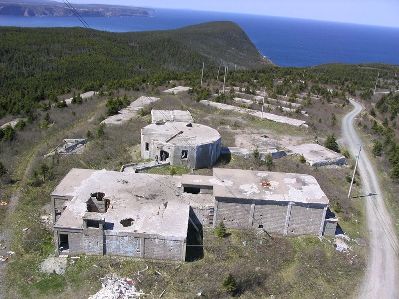
- Aerial photo of the remains at Red Cliff, May 2005. Photo: Tony Roberts.

-

- Aerial photo of the remains at Red Cliff, May 2005. Photo: Tony Roberts.
-

- Remains of the Operations site, May 1998. Photo: Brad Johannessen.

-

- Interior photo of the Operations Building, May 1998. Photo: Brad Johannessen.

-

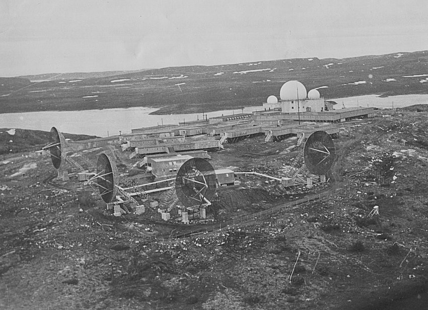
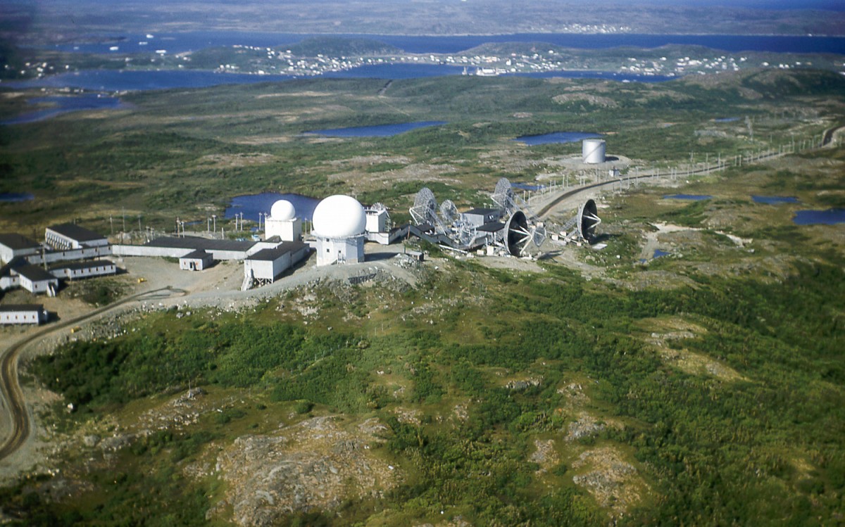
- Headquarters building with radomes in the background, February 1961. Photo: Larry Whitten.

-

- 642nd AC&W Squadron, June 1961. Photo: Tony Devine.

-

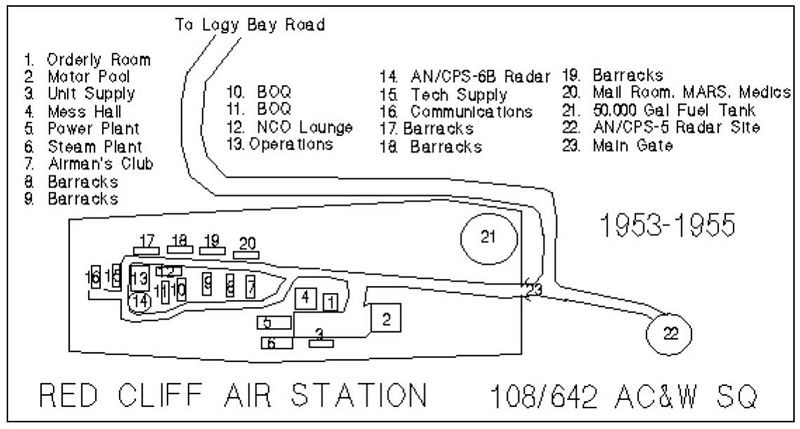
- Base diagram of 108th/642nd AC&W Squadron, 1953.
St. Anthony Air Station (United States Air Force):
Opened in November 1953 as St. Anthony Air Force Station of the United States Air Force, with the radar functions being run first by No. 921 Aircraft Control & Warning Squadron, then 642 AC & W Squadron.
Advances in radar technology eventually made the station unnecessary and as a result. the station closed in June 1968.
The former station in now used by local militia units as a Fighting in Built-up Areas (FIBA) training area. All that remains of the station’s buildings are the concrete foundations.
-

- Aerial photo of the remains of the radar station at St. Anthony, July 2002. Photo: Paul Nopper.

-

- Aerial photo of the remains of the radar station at St. Anthony, July 2002. Photo: Paul Nopper.

-

- Aerial photo of St. Anthony Air Station, 1961. Photo: Robert Shomler.

-

- Aerial photo of St. Anthony Air Station, 1961. Photo: Robert Shomler.
-

- Domestic site buildings with three radomes in background, August 1956. Photo: Ted Sweger.

-

- Aerial photo of the radar station, March 1955. Photo: Wallace Rose.

Seglak Air Station (United States Air Force):
Originally opened in 1953 as Seglak Air Station of the United States Air Force as a part of a the Pinetree Line, with the radar functions being run by No. 924 Aircraft Control & Warning Squadron and supported by Pepperrell AFB at St. John’s, a part of the 64th Air Division. The station was built on the summit of a 500 metre cliff overlooking Saglek Bay.
The radars were shut down on 30 June 1970 and the station closed on 15 September 1970..
Today, there is nothing left of the former Seglak Air Station. A new North Warning System long-range radar station was built several miles away in 1986.
Stephenville Air Station (United States Air Force):
Opened in 1953 as Stephenville Air Force Station of the United States Air Force, with the radar functions being run originally by No. 105 Aircraft Control & Warning Squadron, then No. 640 Aircraft Control & Warning Squadron.
Advances in radar technology eventually made the station unnecessary and as a result. the station closed in June 1971. The operations building and one of the radar towers remain, along with the foundations of other buildings.
What remains can be found on Pine Tree Road, north of Port au Port.
Canadian Forces Station Melville:
Originally opened near Goose Bay in 1953 as Melville Air Station of the United States Air Force as a part of a the Pinetree Line, with the radar functions being run by No. 641 Aircraft Control & Warning Squadron.
The station was a totally self contained facility with fire/rescue, messes, quarters and even a bowling alley. The USAF’s 641st AC&W Squadron was supported by Pepperrell AFB at St. John’s and part of the 64th Air Division.
Northeast Air Command was deactivated 1 April 1957 and replaced by the 64th Air Division; however, all NEAC assets were split up between Strategic Air Command and Air Defence Command (USAF). ADC (USAF) took over the USAF Air Defense Forces including the 64th Air Division.
On 1 July 1971, the USAF relinquished control of the Melville Air Force Station to the Canadian Forces Air Defence Command and re-named CFS Melville, a lodger unit of CFS Goose Bay.
After all the years as a manually operated site, Melville Radar, as it was better known by, was finally SAGE-capable in 1976. This automation considerably reduced the number of personnel assigned to the site.
In August 1984, Melville Radar was brought into the Canada East ROCC.
In 1985 the radar station acted as a tactical control agency in a series of low level flying proof of concept flights with NATO allies.
By 1988, the station was declared redundant with the North Warning System site, located at Cartwright, coming on line. The radar site ceased operations in July 1988.
Little remains today.
Additional source Material: Melville Air Force Station web site – http://www.melvilleairstation.org.
-

- All that was left at the original Pinetree Line radar site, June 1993. Photo: Dave Winter.

-

- Radome on Dome Mountain, July 1998. Photo: Gillian Saunders

-

- Operations site being dismantled, July 1990. Photo: Barry Yager.

-

- Vacated Administration and support buildings with height finder tower in background, March 1991. Photo: Dave Winter.

-

- Buildings at the radar station looking towards RCAF Station Goose Bay, August 1969. Photo: Bernie Pitkin.

-

- Aerial photo of Melville AFS, May 1964. Photo: Doyle Bennett.

-

- Entrance or main gate to Mellville AFS, October 1964. Photo: Bob Caggiano.

Canadian Forces Station Gander:
In February 1954, a Pinetree Line radar station was established at the site of Naval Radio Station Gander, operated by 226 Aircraft Control and Warning Squadron (226 AC&W) of the RCAF.
The establishment RCAF Station Gander resulted in the construction of several new buildings, along with 123 PMQs for RCAF personnel, and the renovation of several existing buildings such as the old USAAF hospital, which was converted in HQ, Corporals Club, Airmen’s Mess and CE storage. This building was again renovated in 1958 and accommodations were added for Senior NCOs and Officers.
As a result of the Unification, RCAF Station Gander was re-named CFS Gander in 1966.
In 1985, the North American Air Defence Modernization Plan resulted in the radar equipment at many Canadian Forces Stations was replaced with a new automated system. As a result, the Pinetree station was slated for closure.
The long-range radar equipment was replaced with an automated Minimally Attended Radar system in 1990 and today, the station operates as a Canadian Coastal Radar station. CFB Gander became 9 Wing Gander in 1993 and today remains a very busy RCAF station.
-

- Operations complex for the Canadian Coastal Radar. from a distance, July 2000. Photo Jim Anderson.

-

- A sign located at the access point for the Operations site, July 2000. Photo Jim Anderson.

-

- Aerial photo of CFB Gander, October 1999. Photo Al Ingram.

-

- Aerial photo of 226 Radar Squadron, 1988. Photo Al Ingram.

-

- Operations site complex, January 1984. Photo Al Ingram.

-

- Aerial photo of radar station, 1972. Photo DND.


10 pings
Skip to comment form ↓