

Canadian Forces Station Kamloops:
Established as part of the Pinetree Line of radar stations in 1958 as Kamloops Air Station and operated by No. 825 Aircraft Control & Warning Squadron of the United States Air Force, one of the many that would make up the Pinetree Line of Ground-Control Intercept (GCI) radar sites.
As a GCI base, the 918th’s role was to guide interceptor aircraft toward unidentified intruders picked up on the unit’s radar scopes. These interceptors were based at the 25th Air Division, Larson Air Force Base in Washington.
On 1 April 1962, the USAF transferred control of the base to the Royal Canadian Air Force as a part of an agreement with the United States that came as a result of the cancellation of the Avro Arrow. Canada would lease 66 F-101 Voodoo fighters and take over operation of 12 Pinetree radar bases. Colonel G.G. Atkinson, Commander of Spokane Air Defence Sector formally handed over control of the station to Group Captain D.L. MacWilliam, representing the RCAF.
Radar operations were taken over by 56 Aircraft Control & Warning Squadron and the base became RCAF Station Kamloops.
Most of the married personnel from the station were housed in the Hidden Valley trailer court in the Rose Hill subdivision of Kamloops. Some families were housed closer to the station in the 8 trailers in a trailer park named McNair Park, in honour of Second World War flying ace Robert (Buck) McNair.
The vacant PMQs at the former No. 15 “X” Depot at Rayleigh had under consideration for use by personnel at RCAF Station Kamloops. As recorded in the station diary for 13 Feb 62, “F/L Stewart visited the former RCAF ammunition depot at Rayleigh, ten miles north of Kamloops with a view to obtaining married quarters area for possible use by RCAF Station Kamloops. He found out that the buildings were on a caretaker basis and in poor state of repair. As the buildings were not habitable and renovation costs would be too high, the project was dropped.”
Radar operations at 56 Squadron were automated on 1 May 1963 with the implementation of the Semi-Automatic Ground Environment (SAGE) system, and the station became a long-range radar site. It would no longer guide interceptors but only look for enemy aircraft, feeding data to the Spokane Air Defense Sector SAGE DC-15 Direction Center of the 25th NORAD Region.
As a result of the Unification of the Forces, the station was re-named CFS Kamloops in 1967.
Beginning in 1983 the station began reporting to Canada West ROCC.
CFS Kamloops closed on 1 April 1988, the 64th anniversary of the Royal Canadian Air Force as advances in technology made the station redundant.
The Station briefly came back to life when the movie “Cadence”, staring Charlie Sheen and Lawrence Fishburne, was filmed at the site in 1990.
The site is now virtually abandoned, except for areas used by Telus, the local TV Station, Kamloops Airport, Forestry, RCMP, and the local Amateur Radio Club for radio communications.
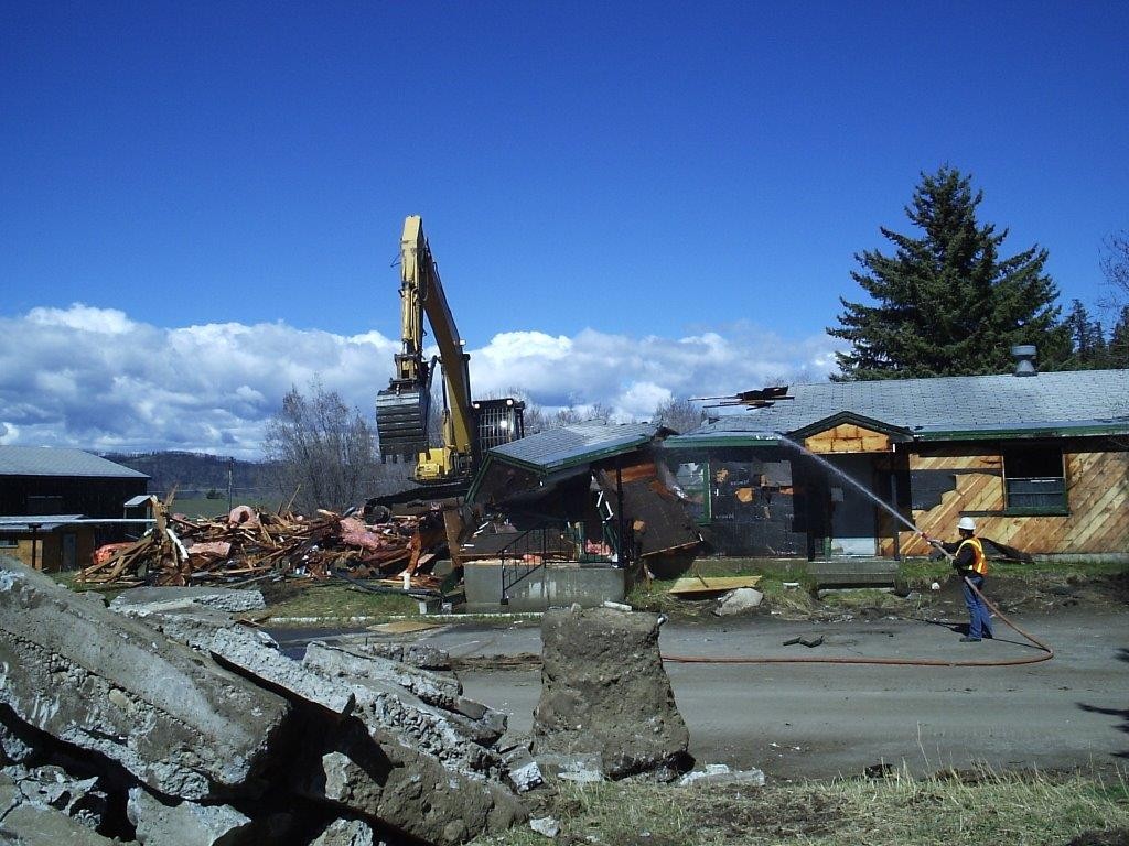
The buildings in the domestic stood until 2005 when they were all demolished, leaving nothing at the site. The city of Kamloops moved the last search antenna to be used at CFS Kamloops, an FPS-20, to Riverside Park as a memorial to the former radar station.
In March 2012, Aboriginal Affairs and Northern Development Canada returned the land to the Tk’emlups Indian Band from whom it had been expropriated and it officially became part of Kamloops Indian Reserve No. 1 in July 2012.
An AN/FPS-20 radar antenna was placed in River Street Dog Park in Kamloops, as a monument to the men and women who served at RCAF Station Kamloops.
Additional source material: DND press release from July 1989, “What’s the story behind that old McNair Park sign?” Kamloops Daily News, 14 March 2012 – What’s the story behind that old McNair Park sign? | Kamloops Daily News (kamloopsnews.ca), information provided by Warrant Officer (Ret’d) Peter Hayes & Mount Lolo – http://wikimapia.org/1246321/Mount-Lolo.
-

- Where the Domestic Area once stood, from the main gate. Photo: Google Maps.

-

- Aerial photo of the domestic area and Operations area. Photo: Google Maps.

-

- An AN/FPS-20 radar antenna monument in River Street Dog Park in Kamloops. Photo: Google Maps.

-

- Old McNair Park sign just before the entrance to the trailer court, 2012. Photo: Catherine Litt,

-

- The Headquarters building being demolished, March 2005. Photo: Courtesy of Warrant Officer (Ret’d) Peter Hayes, CD.
-

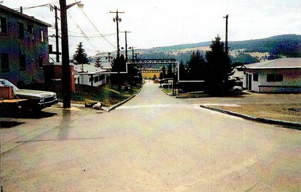
- Looking towards the main gate approaching the domestic site, October 2004. Photo: Dan Port.

-

- Map of the domestic site in 2003.

-

- Kamloops domestic site after building demolished. Google Maps.

-

- Kamloops domestic site after building demolished with numbers denoting their former locations. Google Maps.

-

- West side of the Headquarters building/Canex/Comm Centre, August 1998. Photo: Bob Agar.

-

- Junior Ranks Mess/Recreation Center and the east side of the Headquarters building, August 1998. Photo: Bob Agar.

-

- Kamloops from left to right – buildings 2, 1, 4, 5, 6 & 13 and the main gate, winter 1990-91. Photo: Courtesy of Warrant Officer (Ret’d) Peter Hayes, CD.

-

- Kamloops from left to right, building 6, 5, 4, 3 with swimming pool, winter 1990-91. Photo: Courtesy of Warrant Officer (Ret’d) Peter Hayes, CD.

-

- Kamloops last Station Commanding Officer, Maj Ray Dunsdon at the station parade through downtown Kamloops, 15 April 1988. Photo: Courtesy of Warrant Officer (Ret’d) Peter Hayes, CD.

-

- Warrant Officer Peter Hayes at the station parade through downtown Kamloops, 15 April 1988. Photo: Courtesy of Warrant Officer (Ret’d) Peter Hayes, CD.

-

- Kamloops Station Warrant Officer CWO Skretka at the station closing ceremony, 29 July 1988. Photo: Courtesy of Warrant Officer (Ret’d) Peter Hayes, CD.

-

- Lowering the Canadian flag for the last time, 29 July 1988. Photo: Courtesy of Warrant Officer (Ret’d) Peter Hayes, CD.

-

- Kamloops main gate, building 10 on left, building 6 on right, Mount Lolo centre, 1985. Photo: Courtesy of Warrant Officer (Ret’d) Peter Hayes, CD.

-

- Kamloops just inside the main gate, building 8 on left, building 3 beside it and building 2 of the right, 1985. Photo: Courtesy of Warrant Officer (Ret’d) Peter Hayes, CD.
-

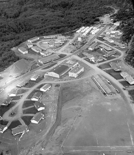
- Aerial photo, 1988. Photo: Photo: Courtesy of Warrant Officer (Ret’d) Peter Hayes, CD.

-

- Building 5 – WO & Sgts barracks and mess, 1985. Photo: Courtesy of Warrant Officer (Ret’d) Peter Hayes, CD.

-

- Kamloops swimming pool, 1985. Photo: Courtesy of Warrant Officer (Ret’d) Peter Hayes, CD.

-

- Aerial view of the Operations Site, 1981. Photo: John Broughton.

-

- Sign at the main gate, 27 October 1978. Photo: Jim Compton.

-

- General view of the domestic site as seen from the road from the Operations site, 12 March 1963. Photo: Air Defence Command Museum.

-

- Barracks in the domestic site, 12 March 1963. Photo: Air Defence Command Museum.

-

- Handing Over Ceremony, 21 March 1962. USAF Captain Eichorn at podium. Behind (L-R) G/C BE Christmas – Senior RCAF Officer at SPADS; Colonel GG Atkinson, Commander SPADS (representing USAF); G/C DLS MacWilliam, CO RCAF Station Cold Lake (representing RCAF) and Colonel Veneziano, Commander, 4602nd Support Squadron, Ottawa. Photo: Keith Carson.

Canadian Forces Station Baldy Hughes:
Opened in June 1953 as Baldy Hughes Air Force Station of the United States Air Force, with the radar functions being run by No. 918 Aircraft Control & Warning Squadron, one of the many that would make up the Pinetree Line of Ground-Control Intercept (GCI) radar sites. The squadron’s role was to guide interceptor aircraft toward unidentified intruders picked up on the unit’s radar scopes. These interceptors were based at the 25th Air Division at McChord Air Force Base in Washington.
Control of the station was transferred to the RCAF on 1 March 1963, radar functions taken over by No. 54 Aircraft Control & Warning Squadron, as part of an arrangement with the United States that came as a result of the cancellation of the Avro Arrow. Canada would lease 66 F-101 Voodoo fighters and take over operation of 12 Pinetree radar bases. As a result, the station was designated RCAF Station Baldy Hughes.
Radar operations at 54 Squadron were automated on 1 June 1966 with the implementation of the Semi-Automatic Ground Environment (SAGE) system, and the station became a long-range radar site. It would no longer guide interceptors but only look for enemy aircraft, feeding data to the Seattle Air Defense Sector SAGE DC-12 Direction Center of the 25th NORAD Region at McChord AFB, Washington.
As a result of the Unification of the Forces, the station was re-named CFS Baldy Hughes in 1967.
The station began reporting to the Canada West ROCC in 1983.
In 1985, DND announced that the Pinetree Line would be shut down as a part of the North American Air Defence Modernization Plan. As a result, CFS Baldy Hughes closed in 1988.
Today the former station is The Baldy Hughes Therapeutic Community and Farm, an addiction treatment centre. Most of the buildings remain, renovated with new façades.
Additional source material: www.baldyhughes.ca
-

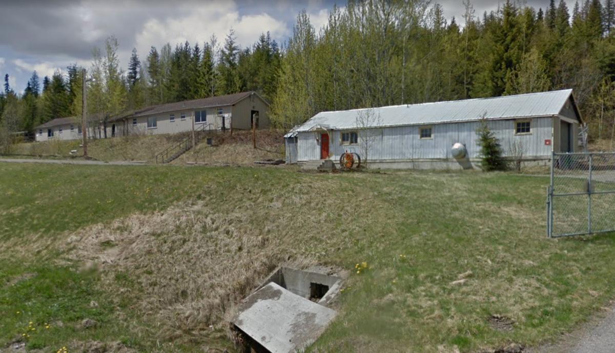
- The gatehouse and one of the barracks, June 2015. Photo: Baldy Hughes Therapeutic Community and Farm.

-

- The “Pink Barracks,” in preparation for new siding May 2011. Photo: Baldy Hughes Therapeutic Community and Farm.

-

- Upgraded buildings, June 2015. Photo: Photo: Baldy Hughes Therapeutic Community and Farm.

-

- Barracks with upgrades, October 2009. Photo: Courtesy of the Baldy Hughes Therapeutic Community and Farm.

-

- Aerial photo of station.

-

- Barracks (left) with garage and car wash area in the background, May 1999. Photo: Bob Agar.

-

- Barracks, converted into a 4-plex apartment, May 1999. Photo: Bob Agar.

-

- Combined mess, May 1999. Photo: Bob Agar.

-

- Inside combined mess, May 1999. Photo: Bob Agar.

-

- Combined Mess and assorted barracks in Lower site, October 1994. Photo: Kris White

-

- Aerial photo of station, 1993. Photo: Sheila Cederholm.

-

- Aerial photo of the Operations site, August 1966. Photo: Jim Davis.

-

- Mess, HQ building and assorted barracks, December 1958. Photo: James “Pat” Patterson.

-

- Assorted barrack blocks, 14 November 1963. Photo: Air Defence Command Museum.

-

- Operations site, February 1962. Photo: Lynwood Cyr.

-

- Photo: Google Maps.

-

- Photo: Google Maps.

-

- Photo: Google Maps.

-

- Photo: Google Maps.

-

- Photo: Google Maps.
-

- Photo: Google Maps.

Canadian Forces Station Holberg:
Opened 1 January 1954 as RCAF Station Holberg, with the radar functions being run by No. 501 Aircraft Control & Warning Squadron, reporting to 5 Air Division located in Vancouver. The station was declared operational on 25 April 1954.
On 1 August 1956, the radar unit became known as 53 Aircraft Control & Warning Squadron. Holberg was later assigned the duties of EW and Ground Control Intercept (GCI).
On 30 September 1957, the squadron took over the area-of-responsibility for RCAF Station Tofino after its closure. The stations role evolved to one of providing data to the SAGE system of the North American Air Defence Command.
In 1958, 53 AC&W became 53 Radar Squadron. Holberg reported directly to the Seattle NORAD Sector of the 25th Air Division and in June 1963, Holberg was equipped with the Semi-Automatic Ground Environment (SAGE) system. As a result of the Unification in October 1967, RCAF Station Holberg became Canadian Forces Station Holberg.
Holberg had been a BUIC site but terminated that phase of its operations on 31 December 1973. They did, however, remain as the back-up to 25 Division at McChord. McChord transferred the 25th Division to Malmstrom AFB, Montana on 21 August 1981 as part of the Regional Operations Control Centre (ROCC) concept.
Holberg began to transmit radar data to the Canada West ROCC at North Bay on 18 June 1983.
Holberg was unique within all of Air Defence Command since it had its own Marine Section due to its remote location on the northern tip of Vancouver Island. When first formed, the Marine Section was fully manned by RCAF personnel. However, after the Unification, the RCAF Marine Sections were disbanded or turned over to Naval personnel. As a result, CFS Holberg became the only station within the Air Defence community to have Naval personnel assigned.
CFS Holberg closed on 17 January 1991, one of the last Pinetree radar stations to close. Holberg was selected as the site for a Canadian Coastal Radar sites, one of four on Canada’s coastlines.
Other than the radar towers, nothing of the former CFS Holberg remains today.
Additional source material: www.holberg.ca
-

- Aerial view of PMQ’s and the domestic site, September 1959. Photo: Ren L’Ecuyer.
-

- Aerial view of PMQ’s and the domestic site, September 1959. Photo: Wally DeMeyer.

-

- Barracks and news stand, 1957. Photo: Bud Hall.

-

- Combined Mess in foreground and barracks in background, May 1956. Photo: Bruce Logie.

-

- Domestic site from nearby hill top, 1957. Photo: Bud Hall.

-

- CF-101 flying over the domestic site domestic site, September 1963. Photo: Eric Sproule.

-

- Main gate, May 1957. Courtesy: Gary Gilchrist.

-

- Rec Centre, May 1957. Photo: Budd Hall.

-

- These apartment buildings provided additional accommodation for married personnel, March 1963. Photo: ADC Museum.

-

- Holberg main gate, 1973. Photo: Sentinel magazine.

-

- Supply ship arriving at the dock at Holberg, 1973. Photo: Sentinel magazine.

-

- Swimming pool in the recreation centre, 1973. Photo: Sentinel magazine.

-

- Aerial view of the station. Photo: Sentinel magazine.

-

- Aerial view of the station, 1973. Photo: Sentinel magazine.

-

- Radar plotter on the cover of Sentinel profiling the closure of the station, 1990. Photo: Sentinel magazine.

-

- Holberg inside the Ops building, 1990. Photo: Warrant Officer Vic Johnson.

-

- Holberg intrim Detachment Commander prior to closure, 1990. Photo: Warrant Officer Vic Johnson.

-

- Holberg kitchen, 1990. Photo: Warrant Officer Vic Johnson.

-

- Holberg Operations site, 1990. Photo: Warrant Officer Vic Johnson.

-

- Holberg just prior to closure, 1990. Photo: Warrant Officer Vic Johnson.

-

- PMQs and a workshop, 1961. Photo: John Jones.

-

- Upper road in the PMQ area in June 2000, roughly from the same place and looking in the same direction as the September 1961 photo. Photo: Jim Ingram.

-

- View of the last remnants of Holberg the Canadian Coastal Radar radome as seen from the access road, September 2004. Photo: Rick Kirkpatrick.

-

- The main gate with the radar tower in the backgrond, September 2004. Photo: Rick Kirkpatrick.

-

- Photo: Courtesy of MCpl (Ret’d) Mike Whaechter, CD.

-

- Photo: Courtesy of MCpl (Ret’d) Mike Whaechter, CD.

-

- Photo: Courtesy of MCpl (Ret’d) Mike Whaechter, CD.

-

- Photo: Courtesy of MCpl (Ret’d) Mike Whaechter, CD.

-

- Photo: Courtesy of MCpl (Ret’d) Mike Whaechter, CD.

-

- Photo: Courtesy of MCpl (Ret’d) Mike Whaechter, CD.

-

- Photo: Courtesy of MCpl (Ret’d) Mike Whaechter, CD.

-

- Photo: Courtesy of MCpl (Ret’d) Mike Whaechter, CD.

-

- Photo: Courtesy of MCpl (Ret’d) Mike Whaechter, CD.

-

- Photo: Courtesy of MCpl (Ret’d) Mike Whaechter, CD.

-

- Courtesy of MCpl (Ret’d) Mike Whaechter, CD.

-

- Courtesy of MCpl (Ret’d) Mike Whaechter, CD.

-

- Courtesy of MCpl (Ret’d) Mike Whaechter, CD.

-

- Courtesy of MCpl (Ret’d) Mike Whaechter, CD.

-

- Courtesy of MCpl (Ret’d) Mike Whaechter, CD.

-

- Courtesy of MCpl (Ret’d) Mike Whaechter, CD.

-

- Courtesy of MCpl (Ret’d) Mike Whaechter, CD.

-

- Courtesy of MCpl (Ret’d) Mike Whaechter, CD.

-

- Courtesy of MCpl (Ret’d) Mike Whaechter, CD.

-

- Courtesy of MCpl (Ret’d) Mike Whaechter, CD.

-

- Courtesy of MCpl (Ret’d) Mike Whaechter, CD.

-

- Courtesy of MCpl (Ret’d) Mike Whaechter, CD.

-

- Courtesy of MCpl (Ret’d) Mike Whaechter, CD.

-

- Courtesy of MCpl (Ret’d) Mike Whaechter, CD.

-

- Courtesy of MCpl (Ret’d) Mike Whaechter, CD.

-

- Courtesy of MCpl (Ret’d) Mike Whaechter, CD.

-

- Courtesy of MCpl (Ret’d) Mike Whaechter, CD.

-

- Courtesy of MCpl (Ret’d) Mike Whaechter, CD.

-

- Courtesy of MCpl (Ret’d) Mike Whaechter, CD.

-

- Courtesy of MCpl (Ret’d) Mike Whaechter, CD.

-

- Courtesy of MCpl (Ret’d) Mike Whaechter, CD.

-

- Courtesy of MCpl (Ret’d) Mike Whaechter, CD.

-

- Courtesy of MCpl (Ret’d) Mike Whaechter, CD.

-

- Courtesy of MCpl (Ret’d) Mike Whaechter, CD.

-

- Courtesy of MCpl (Ret’d) Mike Whaechter, CD.

-

- Courtesy of MCpl (Ret’d) Mike Whaechter, CD.

-

- Courtesy of MCpl (Ret’d) Mike Whaechter, CD.

-

- Courtesy of MCpl (Ret’d) Mike Whaechter, CD.

-

- Courtesy of MCpl (Ret’d) Mike Whaechter, CD.

-

- Courtesy of MCpl (Ret’d) Mike Whaechter, CD.

-

- Courtesy of MCpl (Ret’d) Mike Whaechter, CD.

-

- Courtesy of MCpl (Ret’d) Mike Whaechter, CD.

-

- Courtesy of MCpl (Ret’d) Mike Whaechter, CD.

-

- Courtesy of MCpl (Ret’d) Mike Whaechter, CD.

-

- Courtesy of MCpl (Ret’d) Mike Whaechter, CD.

-

- Courtesy of MCpl (Ret’d) Mike Whaechter, CD.

-

- Courtesy of MCpl (Ret’d) Mike Whaechter, CD.

-

- Courtesy of MCpl (Ret’d) Mike Whaechter, CD.

-

- Courtesy of MCpl (Ret’d) Mike Whaechter, CD.

-

- Courtesy of MCpl (Ret’d) Mike Whaechter, CD.

-

- Courtesy of MCpl (Ret’d) Mike Whaechter, CD.

-

- Courtesy of MCpl (Ret’d) Mike Whaechter, CD.

-

- Courtesy of MCpl (Ret’d) Mike Whaechter, CD.

-

- Courtesy of MCpl (Ret’d) Mike Whaechter, CD.

-

- Courtesy of MCpl (Ret’d) Mike Whaechter, CD.

-

- Courtesy of MCpl (Ret’d) Mike Whaechter, CD.

-

- Courtesy of MCpl (Ret’d) Mike Whaechter, CD.

-

- Courtesy of MCpl (Ret’d) Mike Whaechter, CD.

-

- Courtesy of MCpl (Ret’d) Mike Whaechter, CD.

-

- The former site of CFS Holburg today. Photo: Google Maps.

Royal Canadian Air Force Station Puntzi Mountain:
Opened in 1952 as Puntzi Mountain Air Force Station of the United States Air Force, with the radar functions being run first by No. 917 Aircraft Control & Warning Squadron, then 55 AC &W Squadron. As a Ground Control Intercept base, the 917th’s role was to guide interceptor aircraft toward unidentified intruders picked up on the unit’s radar scopes. These interceptors were based at the 26th Air Division, McChord Air Force Base in Washington.
On 1 February 1963, the station was turned over to the Royal Canadian Air Force as part of an arrangement with the United States that came as a result of the cancellation of the Avro Arrow. Canada would lease 66 F-101 Voodoo fighters and take over operation of 12 Pinetree radar bases. The operating unit was re-designated 55 Aircraft Control & Warning Squadron and the base became RCAF Station Puntzi Mountain.
Radar operations at 55 Squadron were automated on 1 October 1963 by the Semi-Automatic Ground Environment (SAGE) system, and the station became a long-range radar site. It would no longer guide interceptors but only look for enemy aircraft, feeding data to the Seattle Air Defense Sector SAGE DC-12 Direction Center of the 25th NORAD Region at McChord AFB, Washington.
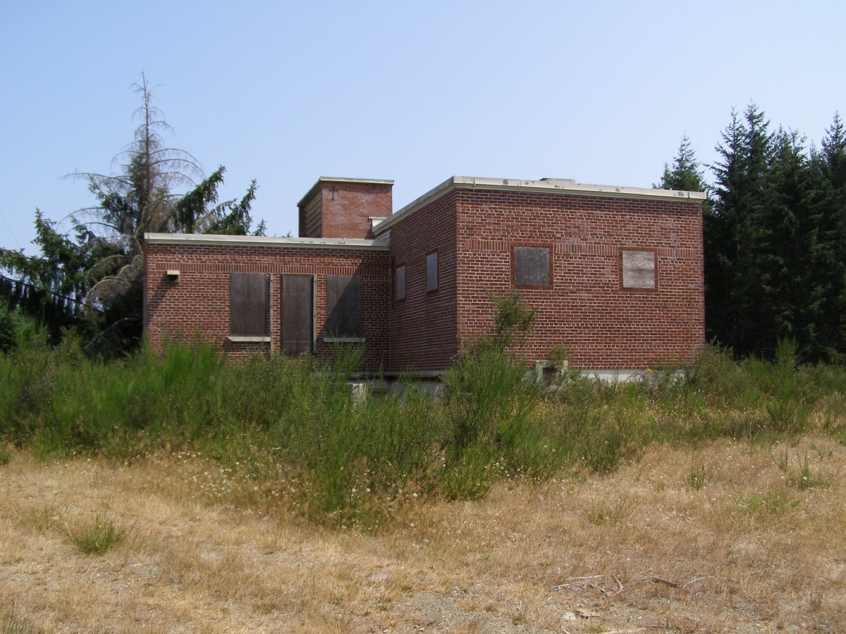
RCAF Station Puntzi Mountain closed on 1 October 1966. The closure was not expected and the community was shocked.
Very little remains of the former station today. The mobile equipment garage was left standing, destined to become a community hall for those who remained in the area. The gatehouse was turned into a pump house. BC Telephone use a small portion for their communications equipment.
-

- Aerial of domestic site june, 1966. Photo: Gary Carlerton.

-

- Guardhouse, 2013. Photo: Paul Loerke.

-

- Guardhouse, 2013. Photo: Paul Loerke.

-

- Inside the Guardhouse, 2013. Photo: Paul Loerke.

-

- Pumphouse, 2013. Photo: Paul Loerke.

-

- Interior of pumphouse, 2013. Photo: Paul Loerke.

-

- Remains of a PMQ, 2003. Photo: Irvine Hill.

-

- Operations Centre, unknown date. Photo Credit: Al Loerke.

-

- The road leading to the Operations Centre, unknown date. Photo Credit: Al Loerke.

-

- The Operations area, 2013. Photo: Paul Loerke.

-

- The GATR site, unknown date. Photo Credit: Al Loerke.

-

- Airmen’s barracks, 1966. Photo Credit: Unknown.

-

- Combined mess, 1966. Photo Credit: Unknown.

Royal Canadian Air Force Station Tofino:
Originally opened 1943 as a “Radio Detachment”, part of a chain of radar stations conducting surveillance of the Pacific Coast. The threat of Japanese incendiary balloons was a significant threat at the time.
Due to it’s remote location, the station had its own airfield, with a squadron for rapid response. Due to the flying hazards presented by the mountainous terrain, a secondary responsibility was crash sight location and investigation. Not one single incendiary balloon was ever recorded in our area. The radar chain was disbanded in 1945 and the station closed.
The station had a very brief existence as it closed on 10 January 1958.
The airfield was transferred to the Department of Transportation. It sat virtually abandoned for many years, but is now the Tofino Airport. Some of the old buildings remain, such as the former maintenance and administration buildings.
Nothing remains of the Operations site today. A plaque was placed on Radar Hill to commemorate the men & women who served with No. 52 AC & W Squadron.
Additional information supplied by Thomas Wagner.
-

- Aerial photo of Tofino airport and domestic site, October 1954. Photo: Frank Handlen.

-

- The sign at the main gate to the station, November 1957. Photo: Cal Booth.

-

- Original building, use (then or now) unknown. Perhaps a mess or barracks, October 1998. Photo Credit: Unknown.

-

- Site of the second Pinetree Line Height Finder, September 2004. Photo: Jim Anderson.

-

- Operations site. Photo: Google Maps.

-

- Operations site.

-

- Administration building at the airport. Photo: Google Maps.

-

- Unknown building at the airport. Photo: Google Maps. Photo: Google Maps.

-

- Maintenance building at the airport. Photo: Google Maps.

51 Aircraft Control & Warning Squadron – Royal Canadian Air Force Station Comox:
51 AC&W Squadron opened in November 1954, originally just outside the north boundary of RCAF Station Comox. As the radar station was close to two other Pinetree stations at Tofino and Holberg, it had a very brief life as advances in radar technology made it redundant less than 4 years later.
As a result, 51 AC&W Squadron ceased operations in June 1958, but the facilities did continue to be used by the Comox Air Traffic Control as a Radar Approach Control (RAPCON) facility on the station.
What’s left of the former 51 AC&W Squadron site can be found along Kilmorley Road, at the north end of the airfield.
The FPN-504 radar equipment was installed in 1968. It has been said that the wind played hell with the huge solid sail, and in a few short years nearly took the top roof off the tower. The following pictures show the system coming down in 1983 in time for TRACS.
Although 51 AC&W Squadron had a brief life at Comox, the squadron was re-formed at 22 Wing North Bay in 1989 where it continues to operate today.
In July 1994, the role of the squadron changed to an Operational Training (OT) squadron and it is now responsible for all operational and general training at 22 Wing.
-

- 51 AC&WS Operations building and two of radar towers. Photo: Google Maps.

-

- 51 AC&WS Operations building and two of radar towers. Photo: Google Maps.

-

- Comox GATR building, 2018. Photo: Ian Kennedy

-

- Comox GATR building, 2018. Photo: Ian Kennedy
-

- Comox GATR building, 2018. Photo: Ian Kennedy

-

- Comox sign. Photo: DND.

-

- Height and search radar towers with Operations building, July 1998. Photo: Ron Guy.

-

- 51 AC&WS Operations building, July 1998. Photo: Ron Guy.

-

- Power Plant building, July 1998. Photo Ron Guy.

-

- FPN-504 sitting on top of cement tower. Original Pinetree Line tower and catwalk in foreground, 1983. DND photo.

-

- Crane arriving to dismantle FPN-504 radar antenna. Original Pinetree Line tower to left of antenna, 1983. DND photo.

-

- FPN-504 antenna sail on its way down. Original Pinetree Line site buildings in background, 1983. DND photo.

-

- 51 AC&WS personnel, 1957. DND photo.

-

- Interior of 51 AC&WS Operations room before installation of equipment, May 1952. Photo Libraries and Archives Canada.


5 pings